Excavation data of the Kremasti ditches
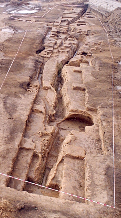
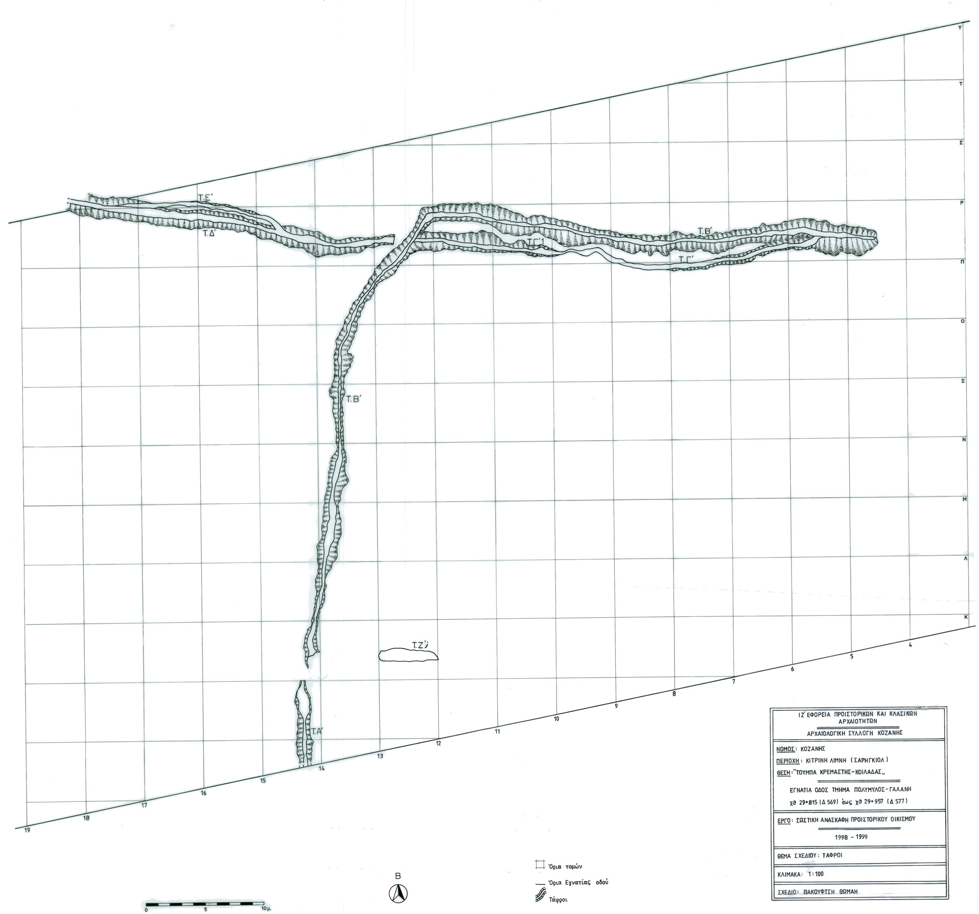
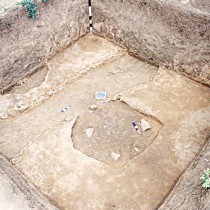
In the excavated part of the Neolithic settlement of Kremasti, a system of seven ditches was brought to light (note 1) (fig. 1, 2). Based on the depth of their initial limit, they date to the three earliest layers D, C and B, suggesting a parallel use with the pits, without however being connected with the original use of this area.
Data related to the ditches is, analytically, as follows:
Ditch A
This is located in the excavation’s central and southern section. 7 metres were excavated at its north end, continuing south beyond the limit of the Egnatia Road and the excavation area. The ditch has a north-south orientation. It is V shaped in cross section, starting with a width of 1-1.60m and ending on the bottom at 0.30m. Its depth is the same throughout all the excavated section, reaching a maximum of 1.60m. The bottom is flat and sandy. Half way up, its walls are irregular and hard, resulting from erosion of the natural clay layer.
Length wise, its stratigraphy is uniform along its explored part, with five thin layers of use between which are two of a clay consistency, resulting from wall erosion. It contains dark brown backfill with few traces of burning and quite a large amount of shells and animal bones, mainly on the two upper levels where they are uniformly distributed. No human bones were identified as clearly linked with the ditch, while there was just a handful of small finds.
Based on the depth at which its limit appears, the ditch can be placed in layer B, the third stratigraphic phase of the area’s use.
Ditch B
It is located in the central and north eastern section of the excavated area, directly north and in a straight line from ditch A, 2.50 m away. Its entire length of 74 m was unearthed. In plan it has an L shape, its two sides being equal (37m), with both a north –south and east–west orientation and a V shaped cross section. The construction has a uniform bottom, with an uneven width of 0.15 to 0.60 m and an approximately 1m incline from edges to centre, where it forms an angle. The bottom’s widest section is on the ditch’s east edge, the narrowest in that of the centre, while from that point up to the south edge the width fluctuates, resulting in four smaller sections between 5 and 16 m long. The two halves of the ditch also present considerable differences as to their initial width. The section with the east-west direction is 1.40-3m wide, and 2-2.50 m at most of its points, while the one with the north-south direction is much smaller, i.e. 1-1.60m, reaching 2m in some sections. The same also occurs with the depth. The first wider section is deeper, between 1.50-2.45m (from the point of the limit’s appearance) with a smooth incline from east to west and a steep incline (of almost 1m) at its west edge, while the narrower section has a depth of 1- 1.40m approximately and deepens abruptly to 2.40m in the section that joins the first piece. The ditch’s bottom consists of loam, while half way up, the walls become hard and irregular, resulting from erosion of the natural clay layer.
Based on stratigraphic data, we may very possibly have originally had two different ditches (the wider, deeper one being that with the east-west direction and the shallower and narrower of the two. being placed north-south) which later became one, following excavation of one or two connecting pieces with an oblique north east to north south direction. It is also possible that these may have been smaller pieces joined with ones in between. While being opened up, the ditch interrupted many earlier pits, as well as ditch C1.
The ditch gradually filled with erosion matter as well as manmade backfill of a diverse content. Some of its parts seemed to have filled up immediately following their opening, while others filled more gradually. According to available data, 14 stratigraphic units are found lengthwise, measuring between 2.50-10m, some of which could correspond to sections of construction, while a partial correlation can be observed between those sections resulting from the width of the ditch bottom.
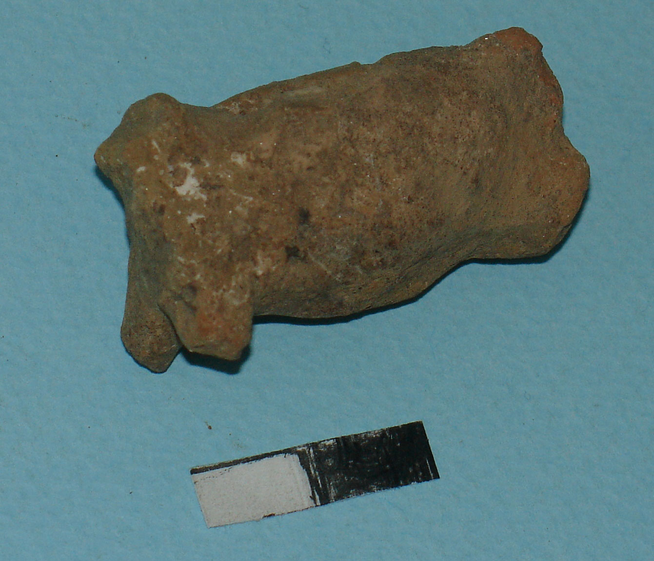
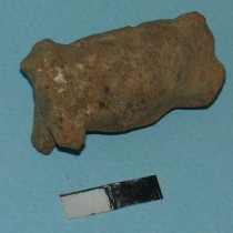
Considerable big and small finds resulted from the ditch, given both its great length and the disturbance, during its opening, of many earlier pits with several finds (fig. 3). Few, however, of these, seem undoubtedly to have been connected with it, a handful of human bones being among them. Chronologically, the ditch’s south section seems to belong to layer B, while the rest appears to be earlier and part of layer C.
Ditches C and C1
It is unclear whether they are sections of the same ditch or two separate ones. They have a similar U shaped cross section and are parallel to the later B ditch, with an east-west orientation. Based on the depth of their initial limit, the eastern section could be placed in the first or next stratigraphic time phase of the area’s use (layer D or C), while the west one could be in the first (layer D).
The earlier C1 section is linearand12.50 m long. Its initial width fluctuates between 0.80m on the edges and 1.50m in the centre, while the bottom has a width of 0.20m to 0.40m respectively. Its depth is 0.40m on the east edge and 1-1.30m on the west one, with an east- west incline of about 0.70m. The walls are vertical and loamy.
Ditch C1 interrupts earlier pits, while its one section is covered over by the backfills of trench B. The backfill related to it is found mainly at the bottom and consists of brown coloured soil. There are quite a few finds (shells, animal bones, a few human ones and several small finds), their origin however is uncertain, because of the existing disturbance.
Section C is curved, with its convex side facing south. It is 19.50m long. Its initial width is 0.40-1m and that of its bottom 0.20-0.50m. The depth is 0.60m on the west edge and 1.10m on the east, with no incline in some direction. The trench’s bottom is flat and loamy in the west section and with an irregular hard clay surface to the east. The walls are vertical.
Ditch C interrupts an earlier pit, while in one cross section its stratigraphy is disturbed by ditch B. Its full length contains relatively uniform backfill, with little erosion material in its deeper section, while its entire height does not seem to have been used. There are several finds which include a few small ones and human bones, of an uncertain origin however.
Ditch D
It is relatively straight, with an east-west direction and in direct continuation of ditch C1, to the west. It is not clear whether D and C1 were joined and then interrupted by ditch B, or if they were two different ditches, as suggested by their structural features.
28 metres of ditch D were explored, while continuing outside the Egnatia Road and the excavation area, to the east/north east. Its full length is not uniform but shows either different U shaped cross sections at different points, or their combination. According to the depth of the initial limit’s appearance, the ditch is placed in layer C, the second stratigraphic time phase of the area’s use. Based on an accurate time correlation between ditches C1/C and B, we could say that the U shaped cross section precedes the V shaped one, while they are interceded by a transitional phase. This supports the hypothesis that ditch D chronologically predates ditch B of the same period (regarding its section with an east-west direction).
The initial width of ditch D is 0.80-2.20 m, 1.80m being more usual, while the width of its bottom changes from 0.30 to 0.60m in the east section and 0.90 to 1m in the west. It is 1.20-1.50m deep with a 0.70 m incline from east to west. In most cross sections it has either a loamy bottom or a hard irregular surface, while the walls are vertical or slanted, loamy or with an irregular surface half way up.
The ditch filled up through time, with both erosion matter and manmade backfill. Three stratigraphic sections result lengthwise, which may correspond either to the same number of construction sections or just two, if we take into account the width of its bottom. This one also interrupts pits whose content remains within. Consequently, there are a great number of finds in its area, most of which, including a handful of anthropological material, cannot be connected to it with any certainty.
Ditch E
This one is almost parallel to ditch A. It is curved, with its convex side facing north and is about 12m long. Its cross section is U shaped, suggesting some early date (layer C perhaps), however, the fact that two out of the three pits it cuts throughare included in layer B, places it chronologically in the same layer, i.e. the third stratigraphic time phase of the area’s use. Its initial width is 0.40m, that of its bottom is 0.20m and it is 0.50 to 0.80m deep. The bottom has a rough surface made of hard clay, while the walls are of loam on their upper section and of hard clay towards the bottom. It contains brown coloured backfill with a minimum of finds.
Ditch F
It is a long, very shallow trench located in a cross section, a few metres east of the south edge of ditch B. It has an east west direction and most probably is part of a ditch. Its backfill is brown, while the east section contains some coal. It could be incorporated in layer B.
Summary of data from the Kremasti ditches C1 (layer D) seems to be the earliest of the ditches. C comes next (layer D or C), followed by D (layer C). Ditch B is later, interrupting and covering C1 and included in layers C and B. Its section with an east-west direction seems to have been constructed first, while that with a north-south direction comes later, with its south end being incorporated in layer B. Also belonging to the same layer are ditch A, possibly E (which probably comes after D) and F. Based on this sequence, It seems that, on the whole, the ditches located in the north section of the excavated site are earlier than those found in the south.
Their inclusion chronologically in almost all the stratigraphic-time phases of the area’s use suggests that ditches and pits are dug simultaneously in the Kremasti settlement. Moreover, the fact that the earliest interrupts older pits, suggests that they are not connected with the original use of this specific area.
Available data shows a gradual opening of the ditches or their sections as well as their gradually being filled with a different content.
Efforts in preservation (re digging) so as to keep them open have not been detected at any point.
Moreover, the settlement is not surrounded (as a single or partial construction) by a group of buildings (according to available excavation data), regardless of their use or location inside or outside the inhabited area. In relation to the part of the settlement that has the form of a low tell and where we believe the habitations to develop, they are located on its boundary and are arranged either vertically or parallel to that, resembling trenches on the boundary or outside the dwelling area, without having an obvious functional connection with the latter.
Furthermore, the following facts result from ditch B, the largest and the most thoroughly excavated in Kremasti.
The ditch was constructed in sections and over time. Its current, final form emerged gradually.
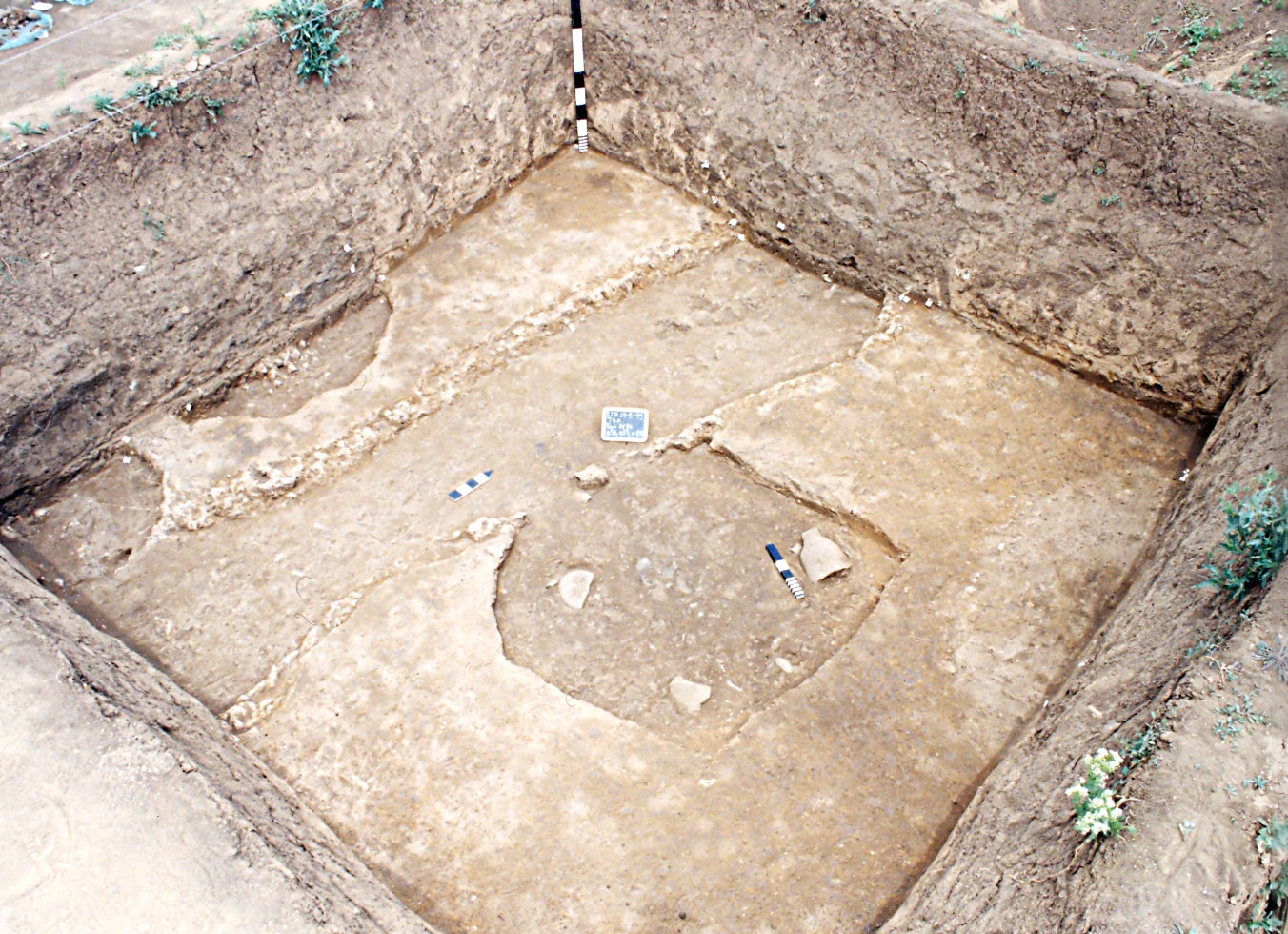
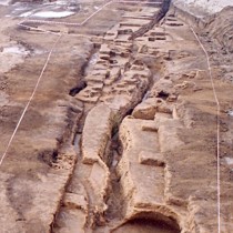
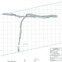
In almost all cases, it disturbs earlier pits as well as a ditch, both of whose content seems to have been deposited somewhere nearby and always inside it. For this reason, the largest amounts of finds are located in sections found near pits. The same applies to ditch D (fig. 4-8).
Large sections of the ditch filled up by layers of erosion without ever having been used for some specific deposition, while some others appear to have been intentionally filled with rubble, immediately following their opening. The erosion observed all along its walls, mainly in the section with an east- west direction, confirms that it remained empty for a long period of time. This was perhaps also helped by its V shaped cross section
Available data suggests that its constructors’ intension was to make a small elongated trench (2.5-10m, based on the stratigraphy of ditch B and 5-22m based on its bottom, while 12.5m are found stratigraphically in ditches C1, D, E and 20 m in ditch C, as well as 11 m and 16m based on ditch D’s bottom). This trench could (perhaps) have been kept open for a long period of time. When, due to erosion, it ceased to serve the purpose (if there had been one) for which it had been opened, it was deserted or filled up (with various refuse from the settlement) and another opened right next to it. However, it is more probable that each time parts of ditches were dug up, it was only to extract material. After that, the trench was left to chance, filled up either with rubble or erosion matter.
It has never been confirmed by stratigraphic data whether ditch B (or the rest) was ever used for burials while open. Burial finds (with very few exceptions) are linked with the higher sections of the ditch’s backfill, when it no longer functioned as an open trench and with areas where earlier pits are disturbed.
Regarding interpretation, the initial function of deposition ditches is not supported by the finds. In few cases, material is found on their bottom that could be interpreted accordingly and such a function should be considered as secondary and occasional. There was also no case of remains of ceremonies with such features as found in pits.
For a series of reasons, the Kremasti ditches could also not be linked to water being transported or pumped from the ground. Nevertheless, it would be feasible for their empty sections to function as rain water reservoirs that would however be difficult to draw from because of their great width, while their possible use as animal watering holes would also be hampered by their great depth.
Consequently, we could assume that the key use was extracting both clay and other material for constructions. In this case, the length of various parts of ditch B, like that of the rest (the smallest unit based on the width of ditch B’s bottom is 5m, while the rest of its sections appear to be 1-4 times its multiples, reaching 22m) could perhaps be predetermined by the size and number of constructions for which the mined material was destined, partly justifying their partial and successive opening. Meanwhile, a similar use would link the ditches with an ideology concerning the house. Their function, besides, in the field of ideology, seems to be supported by other facts such as an orientation based on cardinal points, their linear form (which, when containing water, perhaps resembled streams or rivers) and their location in a site with intense burial and ceremonial activity.
A theoretical approach. Comparisons-Interpretation of the Kremasti ditches
Throughout the Neolithic period the digging of ditches is a particularly wide spread practice all over Europe.
To date, in Greece well known examples were very few and apart from the settlement of Serbia (ditches of the Middle Neolithic and the early Bronze age, (note 2)) were located almost only in Thessaly, in Neolithic and Bronze age settlements, such as the Achilleio (Middle Neolithic), Soufli Magoula (Earlier and Middle Neolithic), Aghia Sophia(Later/Final Neolithic), Otzaki Magoula (Final Neolithic), Argissa Magoula (Later Neolithic, Early Bronze Age), Arapi Magoula (Later Neolithic) and Dimini (Final Neolithic, Bronze Age) (note 3).
The intense excavation activity of recent years in Northern Greece, however, brought to light a large series of ditches dating from the Early Neolithic to the Early Bronze Age.
In Western Macedonia, specifically in the Kozani region, one more ditch (Early or Middle Neolithic) is known to us from the settlement of Kryovrisi Kranidion (note 4), near Serbia, while one important system of ditches was brought to light by the extensive excavation in the settlement of Kleitos (Late/Final Neolithic and Middle Bronze Age) (note 5), sharing a common boundary with Kremasti. In all cases, they are found at the settlement boundaries, while in Kleitos it is obvious that they determine the limits of the early settlement. There is similar positioning and functioning of the ditches in Avgi Kastorias (Late/Final Neolithic) (note 6), while comparable finds also came to light in a settlement of the region of the four lakes in Florina (note 7).
In Central Macedonia, important systems of Neolithic ditches associated with the Early Neolithic have been excavated in settlements of the Neolithic and Early Bronze Age. They are found in the settlements of Giannitsa B, Apsalos, Nea Nikomedeia and Trilofos in Imathia (note 8) and Palia Choani, Aghios Nikolaos in Ritini and Paliambela in Pieria (note 9).
An important place among them is held by the Late and Final Neolithic ditches of Makrygialou (note 10) which surrounded the early settlement, while they are to be found inside the later one. The ditches of its contemporary settlement of Stavroupolis in Thessaloniki (note 11) are also notable, surrounding the settlement in both its phases.
In Eastern Macedonia, the only ditch to have been located is found in Aghios Nikolaos in Thasos (Final Neolithic or Early Bronze Age) (note 12).
Features of ditches from the region of Greece and their integration within the greater European framework
Chronology
In Greece, ditches are dug all through the Neolithic and Final Neolithic period, as well as during the Early Bronze period. Early Neolithic ditches are the oldest in Europe, while the ditches of Italy (note 13) correspond to those in Greece of the Middle Neolithic. Just North of Greece, the earliest of these date to the 2nd half of the 6th millennium B.C. (the Later Neolithic) and are located both in the Vinca settlement (note 14) and the settlements of the Pre-Cucuteni culture (note 15). The rest of the monuments of South eastern Europe date to the Final Neolithic Period in the 5th millennium B.C. They are located on the Northwest edge of the Vinca culture, in Hungary, Rumania and Bulgaria (note 16), as well as in the L.B.K. culture, the first Neolithic culture in Western and Central Europe (note 17). The ditches of Northwest/West Europe (Denmark, England, France), which greatly increased especially during the Early and Middle Neolithic, come significantly later, as in these regions the Neolithic period is placed in the 4th millennium B.C. (note 18).
Association with types of dwelling and space planning
Ditches are located both in tells and flat extended settlements, suggesting the existence of similar or different practices and/or symbolic needs and the attempt to carry them out in the same way. They are placed either inside or on the limits of the settlements.
During the Later Neolithic, they are located on the limits of settlements, often largely or completely surrounding them (Kleitos, Avgi, Makrygialos, Stavroupolis). It is a period when, throughout the whole of Southeast Europe, the boundaries of settlements are usually determined. In most cases ditches are connected with dwelling places, either surrounding larger or smaller settlements and groups of houses, or determining areas inside them. At the same time, there are cases that could be connected with a more particular use of the enclosed space (note 19).
Method of construction
Construction wise, ditches in the form of a single long trench, built in sections when bigger, can be distinguished from ditches that result from separate pits joined in a chain like formation, again reflecting a large series of work episodes.
It has been found that most ditches in Europe have been constructed in the same way. This method of construction in sections is considered by latest research to be central to their interpretation, given that it not support the picture of great works with a predetermined design and function and implying that it could also have social implications (note 20). On the whole, ditches in Europe are made in sections without the simultaneous use of the latter being confirmed, while one or more openings are made, which in cases of complicated constructions are symmetrically placed with a clear reference to the cardinal points (note 21).
In most cases, matter removed from the ditches seems to have been cleared away, suggesting its use (especially of the clay) for the inhabitants’ building activities. In some settlements, however, outside Greece, earth embankments have been located along the ditches (note 22).
Type of walls
The ditch walls are vertical, U shaped in their cross section or slanted, with the latter being V shaped, while a combination of the two can also be observed. The two types also coexist in settlements in different periods of time, without any apparent chronological evolution or a connection with the ditches’ dimensions. The V shaped cross section is found in most ditches in Europe.
Re digging, suggesting attempts to preserve the ditches, is found only in Makrygialos. Apart from Greece, this can be observed in ditches of the L.B.K. culture (note 23).
Dimensions
The ditches’ dimensions vary. Based on their width, one could generally distinguish three categories with possibly a different function: a) narrow ditches of 0.30-1.50m, b) wide ones between 2 and 4.50 m, and c) very wide ones between 8-14m. They have a great variety of depths, of between 1-5.50m, the more usual being 2-3.50m.
Outside Greece, the width of ditches in Southeast Europe varies between 1-8m, their depth being between 0.70-4m. Monuments in the rest of Europe have similar dimensions.
Based on the above (note 24), the deepest and widest ditches seem to be located in Greece, in settlements of the Later and Middle Neolithic, respectively.
Stratigraphy
It is found that all the ditches have been gradually filled up, with their largest section usually covered by erosion matter. In many of them there are signs of erosion and retention of water, which has led many excavators to associate their interpretation with that element. Most archaeological material is gathered in the higher layers of ditches, where concentrations of objects in places or deposits suggest secondary uses that either aimed or led to the filling up of the trench.
The same applies to ditches outside Greece. Differences are noticed not only between places, but also in sections of the same ditch. In some cases a quick filling up with erosion matter is suggested, while in others filling up with rubble is implied or/and deposits of a special nature.
Content
The content of ditches in the region of Greece is varied: Remains of destroyed buildings, piles of stones, shells, animal bones and various other small finds, burned seeds, dissolved organic matter and various forms of anthropological material. The finds are scattered in different layers of the ditches, in different quantities and combinations or they form concentrations corresponding to isolated episodes of use.
Information on the content of pits in Southeast Europe is not always particularly enlightening. Content is usually interpreted as rubble fill and domestic waste, erosion matter and in few cases as intentional deposits. The ditches of the 4th millennium B.C. in Western Europe are considerably different, where many finds are interpreted as special deposits with a significant presence of human bones (note 25).
Approaches to interpreting ditches in the region of Greece
To date, interpretations associate ditches with a variety of functions. Earlier research (note 26) treated them as fortification works for defence against possible attackers (an interpretation that tends to re emerge in some cases), while that of recent times supports their multiple and possibly different functions in each settlement (note 27).
Based on the finds, uses such as extracting clay, disposing of waste, collecting water and burying the dead have all been proposed over the last years. Special emphasis is placed on the ideological dimension of these works, given their potential to function as limits of a space, defining or dividing the habitation area based on space planning, social and symbolic criteria (note 28).
In terms of space planning, in cases of settlements that are flat or shaped as low mounds, it is found that ditches are placed on the limits of the dwelling space, which they also surround. Thus, the outer limit of these types of settlement is defined, whereas such a need does not exist in settlements shaped like tells and with clear outer limits (note 29). In each case, they seem to have been long present in the landscape, making them permanent landmarks and points of reference in the inhabitants’ personal and collective memory. Even if the initial purpose was not to determine the settlement’s limits, some ditches did surround the latter at some point, remaining visible over a long period of time and acquiring symbolic qualities for both the community and the region at large. This resulted not only in their limits’ being made visual but also in their longevity.
Interpreting ditches in Europe
The interpretation of ditches in Europe is associated with their form (as completed works of a predesigned and often standardized type and function, or constructed in sections with use of the latter that is not synchronized and for a different use), their position in relation to contemporary settlements and their association or not with habitation relics, as well as with their content (type of backfill and movable finds. Constructions inside ditches are rare).
In Southeast Europe, ditches’ interpretations move between fortification, their economic significance and a more symbolic function (note 30). In sites of West and Central Europe, they are connected with defence, social organization, economy and symbolic functions (note 31), while for monuments in West/ Northwest Europe of the 4th millennium B.C., a series of interpretational approaches have been expressed that move on two basic axes: the traditional perception that treats ditches as finished works with a predetermined form and function and the latest view; this is based on ditches being constructed in sections which in turn have various forms. This view supports the lack of a predetermined design and the ditches’ active function in the social structure. It is proposed that these structures be treated not as completed monuments, i.e. as an ‘’object’’, but as a ‘’process’’ (note 32) which is a perspective that seems to open new ways to the approach in interpretations of ditches. In Denmark, recent studies see these monuments as a reflection of the habitation type of the surrounding region, associating (in a real or symbolic manner) the ditch sections with families, settlements, groups or land units, while it is probable that the largest of these were the regional settlements’ symbol of unity and social stability, by being occasionally used for burial of the dead, rituals and gatherings (note 33). In England, ditches are considered as walled settlements, cattle pens, places for local feasts, exchange centres, cemeteries and religious centres, but also as monuments that reflect and record social structure (note 34).
In conclusion, the digging of ditches during the Neolithic period is a particularly popular practice throughout Europe. It is difficult to explain the reason for their being so wide spread or for their revival in other regions. Perhaps some symbolic importance was attached to the use of ditches in defining the limits of an area, perhaps, on the other hand, ditches meant different things depending on the place or culture.
Comparison between the data of Kremasti ditches and that of Greece and the greater area of Southeast Europe
Ditches that are contemporary and comparable to those of Kremasti are located only in the region of Northern Greece (including Thessaly). Corresponding monuments of cultures outside Greece are found much further north and seem to be governed by a different logic.
The Kremasti ditches are contemporary with those of the following settlements: Stavroupolis I-II, Makrygialos I, Aghios Nikolaos Ritinis in Pieria, Nea Nikomedeia, Avgi, Arapi, Argissa and Kleitos.
Data comparison reveals similarities in regards to placement on the limits of the settlement, which in the case of Kremasti are not defined, also in the construction of the ditches in sections, the stratigraphy and partly the content. The most significant differentiation is observed in the Makrygialos ditches and concerns the content, since almost all anthropological material is absent from Kremasti, making it impossible to talk of a similar burial site. The relationship, however, between pits and trenches in Kremasti are perhaps not so far from the logic governing ditches A and B of the early Makrygialos settlement, despite their clear morphological differences: In Makrygialos, ditch A is made of a series of pits that were re dug to look like a single furrow (ditch B).In Kremasti earlier pits are found, scattered around and interrupted by later ditches. Namely, similar morphological elements, dictated by similar or different needs, can be used by Neolithic societies in different combinations and relationships to habitation space.
Interpreting the Kremasti ditches
Interpretation of the Kremasti ditches should neither focus on their current form, nor should they be treated as a large communal work constructed at a given moment in time to satisfy a specific need. That is they are not the product of a single “design’’ concept, but resulted through time. We consider as more important their open linear shape which allows them to expand, their orientation according to the cardinal points that might be the ideological basis for their development in space and the contrast they present with the circular and closed shape of pits.
We believe that the reasons for adopting either one or another shape or type of construction must be connected with the type of practical needs they should satisfy (and which seem to be different) as well as the ideological meaning and approach of each of them. The two types have different structural characteristics, advantages and disadvantages. It is possible that ditches were small scale projects shared in common, that satisfied parallel functions, different to those of the pits, of a practical or/and ideological nature.
Thus according to all the data, we believe that the extraction of material for the building activity of the settlements’ inhabitants could also be the initial reason for the opening of the Kremasti ditches, a use that would link them to an ideology concerning the house. Secondary occasional uses are also likely, such as being rain water reservoirs, areas for the disposal of domestic rubbish and possible burial places.
Areti Chondrogianni- Metoki
Dr of Archaeology
Head of the Kozani Ephorate of Antiquities
Ministry of Culture, Education and Religious Affairs