
The Regional Unit of Trikala covers the NW part of Thessaly and its capital is the town of Trikala (fig. 1).
In antiquity, Thessaly was divided, probably by Alevas Pyrros in the 7th century BC, into four tribal states, known as tetrarchs or tetrads. Estiaiotis or Istiaiotis was one of the tetrarch’s four states occupying the district of Trikala almost to its present boundaries. The other states of the Thessalian tetrarch were Thessaliotis, Pelasgiotis and Phthiotis. Archaeological surveys have revealed that the greater area of Trikala just as the whole of Thessaly has been inhabited since time immemorial. Palaeolithic samples of habitation have been found in the Theopetras cave, where there is proof of man’s uninterrupted presence since the Middle Palaeolithic Period (33000-8000 BC) up to the cave being abandoned at the end of the Neolithic period and the start of the Bronze Age (2800 BC). Neolithic sites have also been located near the community of Megalo Kefalovryso, 9 km NW of Trikala and near the village of Zarko in the settlement of Platia Magoula.
Ancient Trikke, the then capital of Estiaiotidas, is identified with the modern town of Trikala and is built on the slopes of a low outcrop of the Xasia mountains with a view across the plain of Thessaly. Its position was of particular strategic importance because it controlled the passes from Epirus towards eastern Thessaly.
Archaeological data to date indicates that the ancient settlement proceeded to develop between the Lethaios river and the hill on whose peak stood the Byzantine castle. According to excavation trenches opened from time to time in the area, the earliest habitation layers date from the early Bronze Age.
The most ancient written reference to ancient Trikke comes from the Homeric catalogue of ships where there is reference to the city participating in the Greek campaign to Troy with 30 ships, led by Mahaonas and Podaleirios, the sons of Asclepius (note 1). Generally speaking, when the ancient writers refer to ancient Trikke, they primarily relate it to the worship of Asclepius and various events of their period.
Very few facts are known about the city’s history during the first centuries of Christianity. In 1956 while opening a ring road a half destroyed mosaic floor was found, whose original length and width could not be determined. To the North and West of the floor, masonry was located with marble covered walls (note 2). The mosaic could be dated from the mid 5th century BC by analysing its ornamentation and comparing its motifs to corresponding ones. These remains are not preserved today. In general however it seems that Trikke was in decline during that period and this is why the emperor Justinian, valuing the town’s strategic position, built its castle in the 6th century AD (note 3).
In the Middle Ages the town was raided and pillaged by Goths, Huns, Slavs, Saracens, Normans and Franks while in the second half of the 14th century the region was occupied by the Serb king Stefan Dusan (1331-1355). Next, in 1395, Trikala came under Turkish rule, during which, following approximately two centuries of decline, the town evolved into an important economic centre for the rest of the Turkish occupation, as certified by the existing monuments. Trikala was liberated in 1881 and following the 1897 war was reoccupied by the Turks till its final liberation in 1898.
A presentation of the sites in the town of Trikala
The archaeological site of ancient Trikke
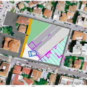
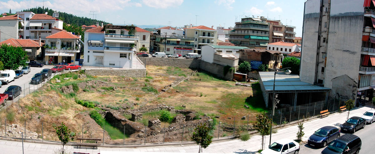
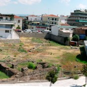
The archaeological site of ancient Trikke is located in the centre of the modern town of Trikala and specifically in the area south of the castle next to the cathedral of St Nicolas (fig. 2).
The first surveys in Trikke to locate the Asclepeion which was well known for its springs began at the end of the 19th century just after the discovery of the Asclepeion in Epidaurus. Specifically, members of the German Archaeological Institute in Greece came to Trikala in 1892. They located ancient structures and collected moveable clay statuettes on the left bank of the Lithaios river about 200 m SW of the Byzantine castle in a place known as “Gourna/Bowl”. Among these was a Ceremony Official (Telesforos, a rooster and a baby in swaddling clothes, all related to the worship of Asclepius (note 4).
In the years that followed, surveys were conducted first by P. Kastriotis and then by A. Arvanitopoulos. In 1958, 1964, and 1965 D. Theocharis opened excavation trenches in public and private spaces to locate the sanctuary of Asclepius. Sections of Hellenistic and Roman buildings were discovered which tentatively were attributed to the Asclepeion.
Last, after 1976, the 15th Ephorate of Prehistoric and Classical Antiquities which had previously been in charge, continued surveys in the form of rescue excavations and completed the discovery of the buildings located by Theocharis.
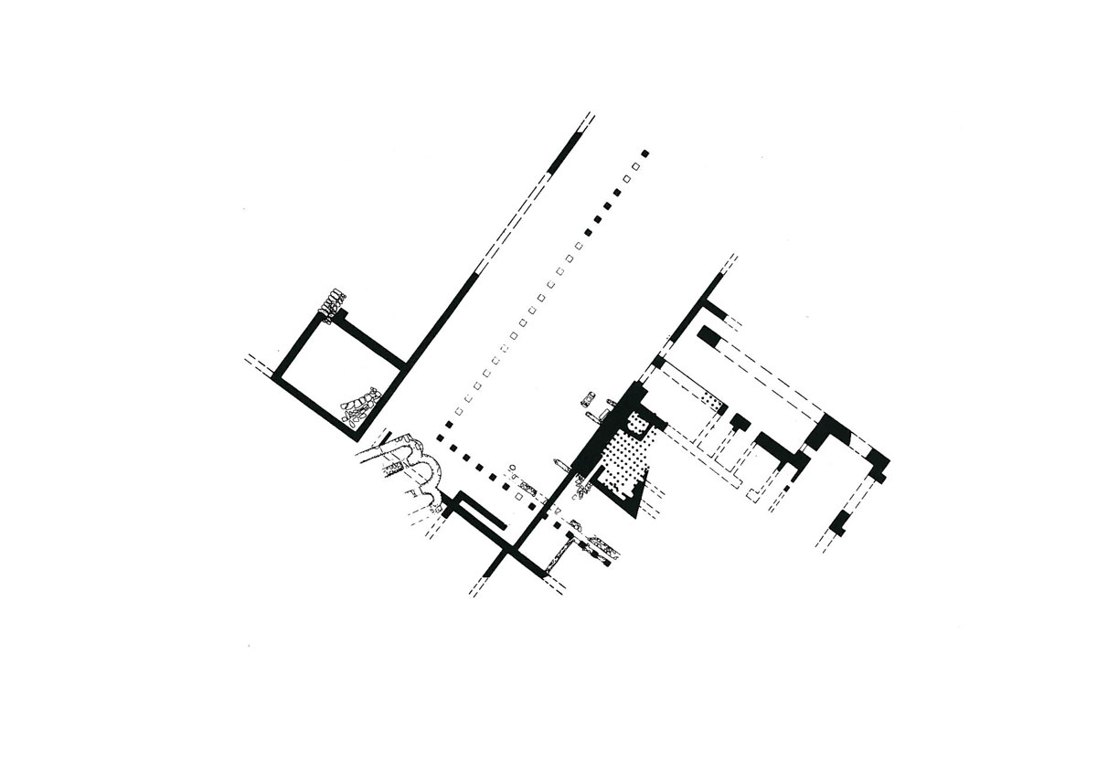
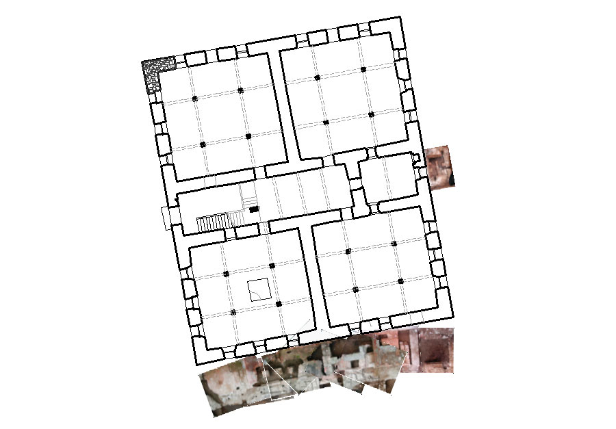
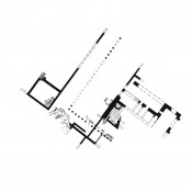
In the existing archaeological site, sections of four buildings have been located: a building with mosaics, an arcade, baths and the remains of a church (fig. 3). More specifically:
The Hellenistic building: On the Northern side of the archaeological site is the linear Hellenistic building with floors decorated with mosaics. Its foundations are parallel to the arcade which is its contemporary. Specifically, the two buildings are shaped like parallel islets belonging to the Hellenistic Hippodamian city planning system. Its dimensions, to date, are 45,40×12,70 while its extension to the NE is under plots of land and building sites. Its walls were made up of sandstone blocks and the superstructure of unbaked bricks built with mud. There had been two main phases in its construction with some provisional repairs.
In the first phase, its interior was divided into rectangular halls by vertical walls, while in the second, the building’s partition walls were removed uniting the rectangular halls in its interior. The floor was also raised by 0,40 m and decorated with mosaics depicting scenes from the Dionysian cycle and a great variety of decorative motifs. The mosaics crafting can be placed in the second quarter of the 3rd century AD.
The Hellenistic Arcade: The arcade stretches the full length of the archaeological site. One wing starts at the SE end with a NW orientation while it then bends and goes in a NE direction. Its beginning and end have not been found till today. Most probably the arcade was actually made up of a row of columns, because the bases made of sandstone blocks do not bear traces of lugs for the fixing of columns.
The arcade’s wings were surrounded by an open air courtyard which had a gravel floor. The space between the wall and the row of columns had an identical floor. Based on the ceramic remains its construction can be placed in the first half of the 1st century BC. It is believed that this arcade belonged to the gymnasium of ancient Trikke.
Researchers suppose that on the not yet discovered SE side of the open air courtyard there must have been an entrance (propylon) and seats which were in fact amphitheatrically placed platforms for spectators. At the end of the 3rd century AD the arcade must have been abolished because the bath complex was constructed on its southern side.
The Roman bath: It occupies the Southern part of the archaeological site. Its dimensions are 40,50×30,50 m, the height of its walls varies from 1,50 to 3,05 m, and their width approximately from 1,20 to 1,50 m. Its masonry is made up of rough stones on the lowest section and optoplinths on the upper one. A pinkish coloured plaster was used as a binder.
The hot area or caldarium has been preserved, the basement area of the hypocausts, the luke warm area or tepidarium and the rectangular hall that made up the room for resting room, while the cold area or frigidarium has not been located. In addition, several sections of the bath complex as for example the changing rooms, the latrines (vespasians) and the monumental entrance have not been found and there is speculation of their being under the modern day construction sites and the adjacent roads. The Roman bath was made at the end of the 3rd century AD while additions and repairs are dated a century later.
To sum up, the exact use of the Hellenistic building and the arcade cannot be determined with certainty based on data from excavations to date. Moreover, at this stage it is not possible to connect the above buildings. In all certainty, to the sanctuary of Asclepius as the latter’s place has not been located. Nevertheless, according to the last person to excavate the site, these particular buildings are on the whole for public use and can be attributed to the organized complex of buildings of the Asclepeion in Trikke, known to us from sources of reference (note 5).
The Basilica on the site of ancient Trikke: a three aisled basilica of the middle Byzantine era was located to the West of the Hellenistic arcade. The inner sanctuary area to its east ends in three semicircular arches. Sections of the two walls dividing the aisles were found in the interior and these most probably supported a colonnade. Both arches and walls are built of rough stones, tiles and use mortar as a binder, while reused structural members have been located.
The state of preservation
Today the monuments that make up the archaeological site are not properly preserved. Particularly in the case of both the Hellenistic building and the arcade only the foundations have been saved and in certain places these are so badly preserved that the restoration of the ground plan is made difficult. The remains of the Roman bath are in better condition and have maintained more of their original height. They cannot however be easily observed because of the way in which the shelter for their protection has been placed.
The Ministerial Decision no 12524/9-12-1964 (ΦΕΚ 38/Β/19-1-1965) has declared the remains of ancient Trikke an archaeological site. The 34th Ephorate of Prehistoric and Classical Antiquities currently acts as an agency for its protection.
The Castle
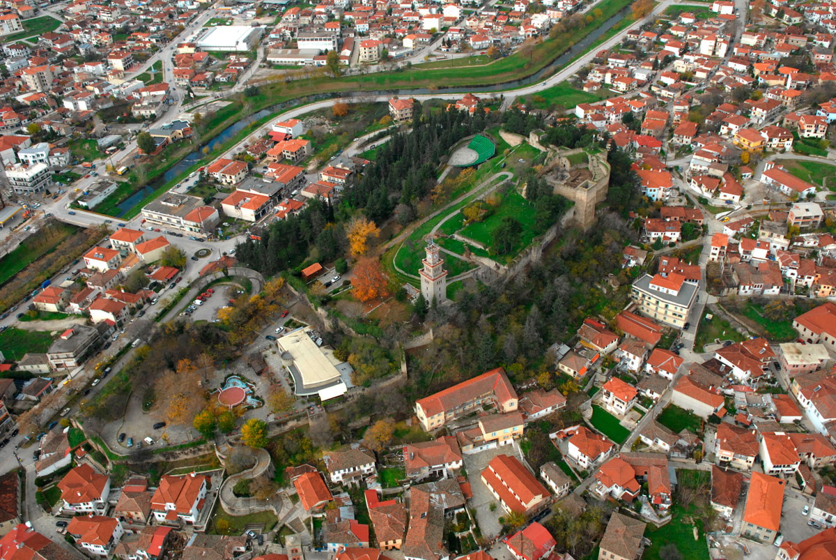
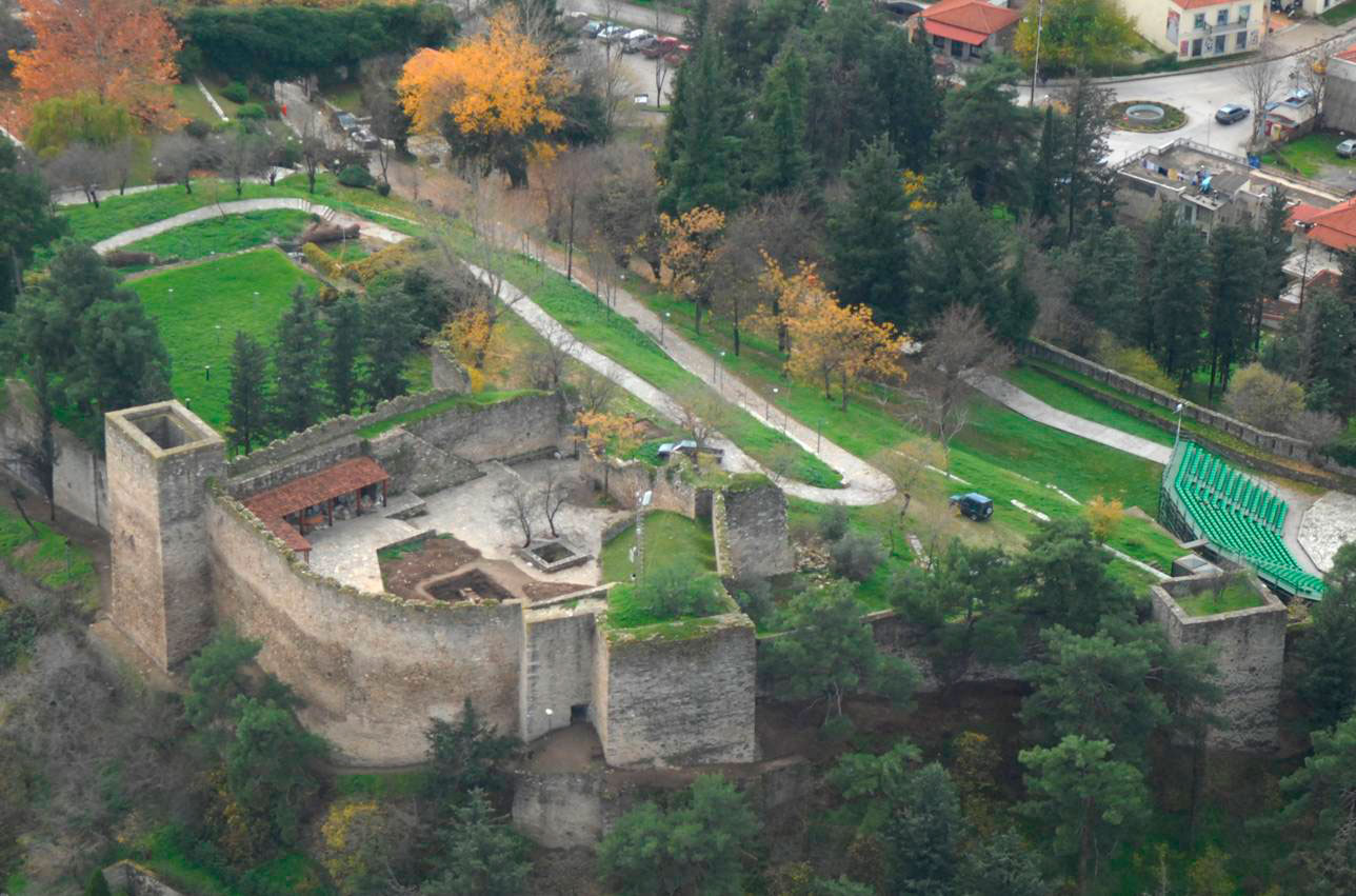
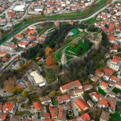
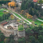
The castle of Trikala is situated in the NW part of the town and is built on top of a low hill to the west of which flows the river Livaios (fig. 4). According to those who studied the history of the town of Trikala, the castle replaced ancient Trikke’s citadel whose remains are prominent on the West side of the fortifications. Moreover, the use of boulders in the masonry confirms the above opinion.
The castle occupies an area of almost 2,5 acres and is a typical form of Byzantine fortification. It has an oblong polygonal shape, with an axis from SW to N (fig. 5). Four sided towers strengthen it at intervals blending organically with its walls. On the inside it is divided with transverse walls into three sections: a) a first, bottom, level which is situated on the lowest part of the southern slope of the hill, b) a second, middle, level which is the longest and c) the small inner fort, the ic kale, or third level, which is situated at the top of the hill, in the NE corner.
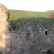
The castle’s masonry consists of a simple rubble wall of partially hewn limestone constructed according to the pseudo-isodomic system by inserting smaller bricks. Its entrance gate, arched with a stone door frame is situated on the first level’s west side. A new entrance was opened on the castle’s east side during the 1960s, so as to facilitate access from the side of the modern town.
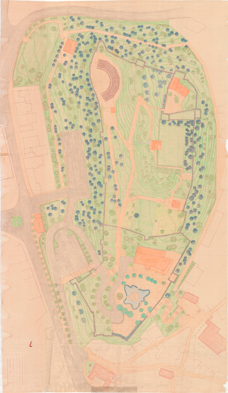
More specifically, the first level is occupied by both the SW part of the castle and a part of the E section. A tourist pavilion was made there in the 1970s and is still in use.
The area’s middle part takes up the second level. Near its inner east side a large clock resembling a tower, now demolished, was built in the mid 17th century. The existing clock was built on the same spot in 1936.
The Ministerial Decision no. 1653/43009/12-9-1978 (ΦΕΚ 804/Β/21-9-1978) has declared the castle a listed historical monument, as it is both of great architectural interest and an important monument for the town of Trikala. Following the Ministerial Decision no ΥΠΠΟ/ΑΡΧ/Β1/Φ32/23256/568/13-12-88, an open air theatre with a metal structure was built in the same area where performances and concerts take place during the summer months.
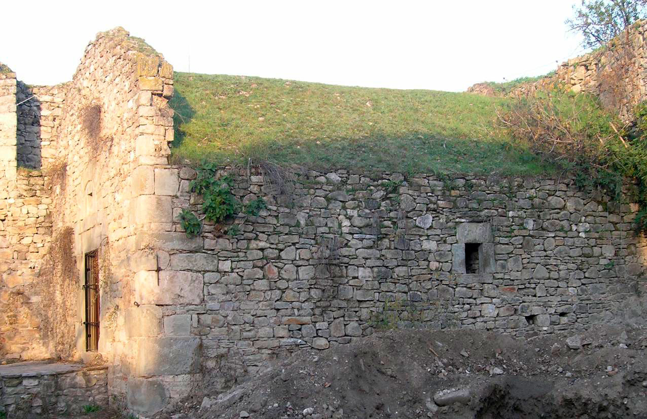
The third level is the most important as it is prominently placed with an overall view of the surrounding region. It occupies the highest point of the fortress on the NE and is shaped like an irregular quarter of a circle with a perimeter of 174,00 m and a total height, up to the battlements, of 15 m. The entrance is situated on the west side while its walls is reinforced with four towers (fig. 6).
A natural embankment, on the inside, led to the ring road on the east and north side which was paved at a later date and successive landings were formed. Last, a narrow flight of steps leads to the ring road on the south side. The Arsenal is situated on the west side of the interior. This is a single space vaulted hall (fig. 7) measuring 7,95×11,15 m. Its entrance is on the north side and has a stone door frame. Over the entrance there is stone decoration, with an opening for ventilation in its centre.
An elevated plateau is formed in front of the entrance while a flight of steps leads to the basement. Ancient building materials have been used on the bottom section of the Arsenal’s masonry, while the rest of the sections were made of rubble walls with a limited use of unbaked bricks.
Due to successive modifications made on the fortifications during the Ottoman period it is difficult to distinguish earlier construction phases.
Nevertheless, the Justinian era (540 AD), when building material from the ancient citadel was used, can be deduced as the first phase, whose remnants have been detected on the citadel’s west side. The second construction phase can be placed in the late Byzantine era where a concentrated use of bricks in the horizontal and vertical joints is a particular feature of the masonry. The third is in the Ottoman period during which the castle was extensively repaired.
The state of preservation
Nowadays, the monument is, on the whole, well preserved, especially in the places on the first and second levels where, in the past, the Municipality of Trikala and the previously responsible 7th Εphorate of Βyzantine Αntiquities carried out work on the walls’ maintenance and restoration. The interior of the space on the second level has been also been redesigned with visitors’ walks, resting spots etc. since the clock tower and the theatre attract quite a few visitors.
Certain rescue operations were carried out on the third level in 1981, but on the whole, the walls of the inner and outer fortified enclosure are badly preserved. The stones are worn and corroded, sections of the towers have collapsed, the binding mortar is worn except for the particular spots that have been preserved, as previously mentioned. In addition, gaps can be seen, at intervals, in the masonry as well as cracks in various places.
To conclude, the following modern interventions have been made on this third level’s floor: a) the paving of the open space in front of the Arsenal building and its SE section, b) the design of a square “sunken” platform just after the entrance and c) the design of a platform on the south side and adjacent to the stone flight of steps which is covered with a tiled porch.
Varousi
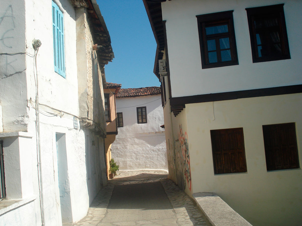
The traditional district of Varousi extends along the castle’s east side and was the town’s Christian district during the Turkish Occupation. The mansions in Varousi and its many churches from the post-Byzantine period reflect the economic boom in the 18th and 19th centuries resulting from the development of trade and crafts (fig. 8).
The district’s urban grid must have originally been denser since safety reasons required its development close to the castle. Judging by the building layout, there seems to have been no formal planning. The streets branch out between the houses and create narrow alleys known as “Sakaflia’s alleys”. Their irregular shape often changes the corners of the buildings’ ground floors making the floor above protrude at an angle.
The houses are usually placed in front of the street, while on more rare occasions the courtyard faces the street and the house is at the back, just as today. The outer side of the houses’ ground floors has no openings for safety reasons and the courtyards have high walls which create the impression of a continuous system of buildings, although the houses are not always connected to each other.
The houses are built mainly of stone and wood and less often of bricks of clay and adobe. The walls of the ground floors are built of stone and their width varies between 60-90 cm while they are reinforced at intervals with horizontal joists. The stonework was usually coated with mud and straw and then covered with plaster of different colours, while in rare cases the masonry was untreated. On the whole, however, one does not encounter the carefully chiselled masonry found in the mansions of other towns.
The walls on the first floor as well as the indoor partitions on the ground floor are made of a light wooden construction, known as the tsatma or bagdati. The floors at ground level are covered with stone slabs or are of packed earth while those of the upper stories are wooden. The roofs are wooden covered with tiles of the “Byzantine” type, they have a 30% inclination and their cornices protrude 20-90 cm for the flow of rainwater and snow.
The key morphological feature, however, is the so called “sachnisi”, the jutting out of the first floor which in order to save space can have either a rectangular, triangular or trapezoidal shape. Moreover, at the end of the 19th century, due to the effect of neoclassicism, small iron balconies were added on to many houses.
Because, as mentioned before, this was a Christian district of Trikala during the Turkish Occupation, the churches surviving today in the area of Varousi are the following: St Demetrios dating from before 1588, Aghios Ioannis Eleemon (St John the Merciful) and Aghios Panteleimon which dates from between the end of the 16th century to the start of the 17th century, Aghios Ioannis Prodromos (St John the Baptist) (1674), Aghia Marina (1766), Aghia Paraskevi(1843) Panagia Faneromene or the church of the Nativity of the Theotokos (1849-1853), of Our Lady of Episkepsis (the Visit) (1863-1877) and Aghios Stephanos built over an earlier church which had been constructed by Simeon Ouresis Palaiologos in the 14th century and was destroyed by fire. During most of the Turkish Occupation, St Stephanos was the seat of the Bishop of Larissa. The present church was built in 1882. Last, the church of the Agioi Anargyroi is a three aisled basilica with a wooden roof, built on a high spacious plateau. Inside, the aisles are divided by segments of wall. According to the donor’s inscription “it was fundamentally renovated” and was decorated with frescoes in 1575. The original building was a single space with a three sided apse facing east. In the next phase the side aisles were added and all the building was raised. The church’s interior is decorated with frescoes. The dates of those in the main church and the narthex are 1575 and 1627 respectively.
Despite the fact that most of the buildings making up the district have been preserved, its physiognomy, in general, has deteriorated. This is mainly because buildings with a different aesthetic approach were constructed in the 1970s and 1980s and have been inserted among those belonging to a traditional architecture. Moreover, many buildings collapse because of damage as their owners are either not interested or unable to bear the cost of their maintenance. The churches that are located in this particular district are well preserved as they are in use and preserved by the Metropolis responsible for them in collaboration with the 19th Ephorate of Byzantine Antiquities.
Varousi has been declared a protected traditional settlement, according to the Presidential Decree published in both the ΦΕΚ 201/Δ/5-4-1979 and the ΦΕΚ 886/Δ/25-8-2005.
Osman Shah Mosque
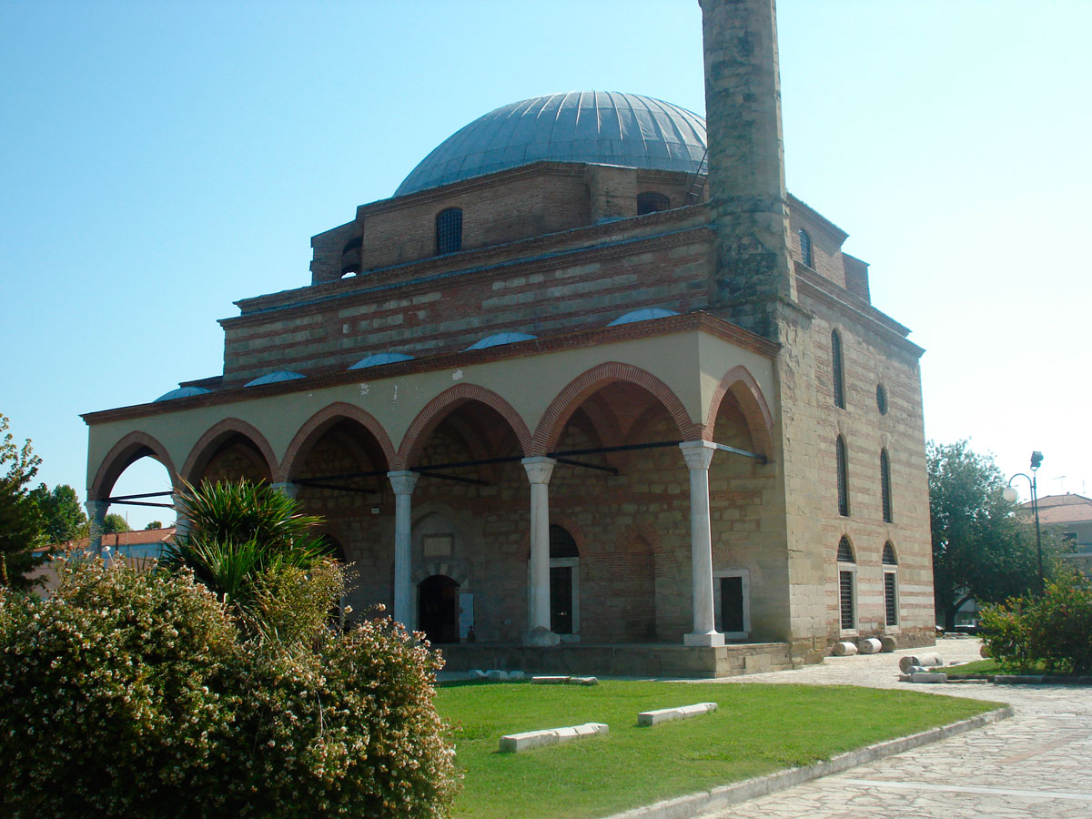
The mosque of Osman Shah, better known as the Koursoum Camii (the lead mosque), is situated at the entrance to the town as one arrives by the national motorway from Karditsa to Trikala (fig. 9). It was constructed by the Turkish governor of the region, Prince Osman Shah, nephew to the Sultan Suleiman the Magnificent, designed by the famous Turkish architect Koca mimar Sinan.
According to the Book of Journeys by the Ottoman traveller Evliya Çelebi Seyahatnâme, Osman Shah’s endowment included a seminary, a poor house, an inn, baths and other charitable institutions, which, however, cannot be located, as the layout of the streets in the district has changed. As a result, most of the above buildings have today been demolished and new ones put up in their place. Moreover, no excavation survey has ever been realized in the immediate area surrounding the monument.
The Mosque is a magnificent cube shaped, domed building with an overall height of approximately 22,5 m with a porch supported by columns, known as the revak, and a minaret on its west side.
The main hall is covered by a semi spherical dome made of bricks without scaffolding, while arches are formed on the top part of the walls to support the spherical triangles. The heptagonal niche of the mihrab is formed on the inside of the east wall and it is surrounded by a rectangular frame on which can be found the remains of floral decoration in plaster.
The exterior of the dome is covered, up to a certain height, by an octagonal pseudo-tympanum (drum) while on the four sides that correspond with the spherical triangles, arched buttresses have been constructed so as to control its pressure. Moreover part of the pressure created by the dome is transferred through the circular base and the spherical triangles to the four corners of the supporting structure, while another part of the pressure is transferred to the walls on the perimeter through arched buttresses. The top of the dome is covered with sheets of lead.
The mosque’s masonry is of greenish chiselled tuffstone, interchanged with three rows of bricks jointed with reddish mortar. On the north, east and south sides of the masonry three rows of windows have been opened, while there is only one row on the west side because of the existing porch.
As previously mentioned, a porch, known as the revak, extends on the monument’s west side exceeding the length of the mosque so as to also include the base of the minaret situated in the SW corner. A similar approach to construction is encountered in Konya in the Selimiye Camii which dates from the beginning of the 16th century as well as in other works of Sinan (note 6). The minaret is made of chiselled tuffstone with a quadrilateral lower section and a polygonal higher one.
South of the mosque is the mausoleum (turbesh) of Osman Shah’s family (fig. 10). It is an octagonal building made of rubble walls whose corners on their exterior are covered with a layer of decorative stone patterns. On its six sides are windows of a similar style to those of the mosque. Its entrance is on the west side in a recess under a low semicircular arch, while the only side of the mausoleum with no openings is the one facing Mecca.
The exact date of the mosque’s construction is not known, in a record, however, of Osman Shah’s assets of the year Egiras 974 (1566-1567), it is mentioned that the mosque was already functioning. The adjacent mausoleum is dated approximately a decade prior to Osman Shah’s death in 1567-8.
The state of preservation
The monument is excellently preserved, as it has been restored by the 7th Ephorate of Byzantine Antiquities formerly responsible for it. It is worth noting that it is the only surviving Ottoman mosque in the town of Trikala and the only mosque designed by Sinan to survive on Greek soil. Today it is used for cultural purposes, mainly for housing exhibitions. It has been declared a listed historical monument with the Royal Decree 30-5-1936 (ΦΕΚ 245/Α/8-6-1936) and the agency responsible for its protection is the 19th Ephorate of Byzantine Antiquities.
The Ottoman Baths
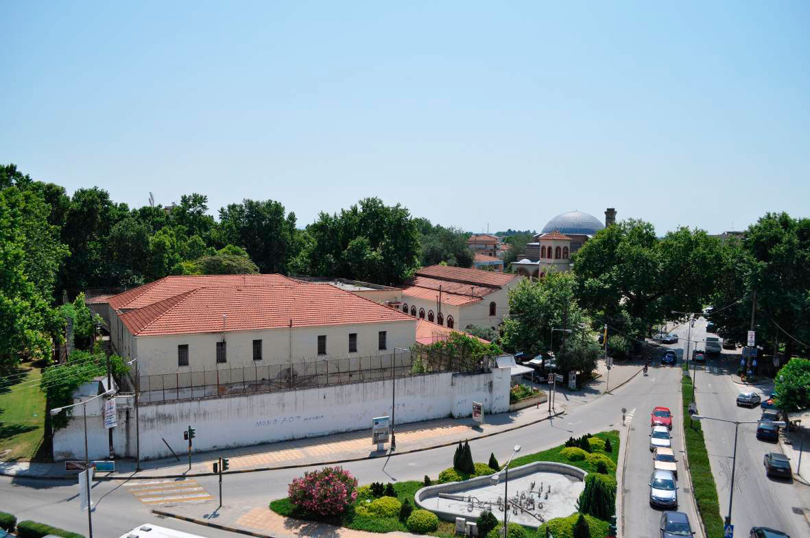
To the west of the Mosque, near the more recent church of St Constantine is the former offenders’ prison complex of Trikala. It is made up of a central two storey building surrounded by a high wall with watch towers on its four corners. The two storey prison administration building is situated on the precinct’s south side and in the centre where the prison’s entrance is to be found, while the church of St Eleftherios and auxiliary buildings are situated in the grounds’ NE side (fig. 11).
The reconstruction of the central two storey prison building started in 1901, while its current form emerged following the catastrophic 1954 earthquake. Recently, the Technical Services of the Municipality of Trikala conducted a study with a view to reusing the building as the “Vassilis Tsitsanis” Museum and Research Centre.
According to a topographic chart of 1885 there was a Bath where the main building of the former Prison now stands. For this reason, the 19th Ephorate of Byzantine Antiquities made a survey of the ground floor to establish the presence or absence of earlier phases. After the removal of successive layers of plaster it was found that the Prison’s ground floor is, in fact, twin Ottoman baths with an area of approximately 850 square meters and can probably be identified as the Bath of Osman Shah as mentioned by Evliya Çelebi in his Travelogue and obviously one of the Prison’s buildings.
The Bath complex is a rectangular building made up of two sections, the men’s on the South side, the women’s on the North (fig. 12). Each section consists of three areas, namely the cold, the warm and the hot. Evidence, so far, has shown that it is quite a compact building that follows the layout of corresponding ottoman baths dating from the 15th to the 17th c (note 7).
Today the monument is problematic both aesthetically and functionally because of interventions and additions made to it when converted into a Prison. Specifically, the domes and parts of the walls were removed, the original openings were altered, decorative features were removed as well as the original floors, an extra storey was added, etc.
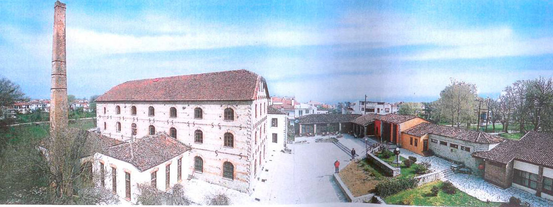
The Matsopoulos Mill Complex
The “Matsopoulos Mill” is located at the west end of the town of Trikala next to the Agiomoniotis river and specifically in the region between the railway station and the Aghia Mone quarter. The complex with its surrounding space takes up an area of almost 22,5 acres.
The building complex of the “Matsopoulos Mill” consists of the main water mill and is surrounded by auxiliary buildings which form an enclosure (fig. 13).
All the buildings are made of stone with wooden roofs covered with “Byzantine” or “French” tiles. Bricks in various combinations are extensively used in the masonry.
The water mill’s main building has four levels and is covered with a wooden, trough-shaped roof. Its corners are enhanced by alternating sandstone cornerstones while the remaining section of the masonry is decorated with bands of stone, three to each storey. The storeys themselves are divided for aesthetic reasons by bands of brick which also bare a toothed frieze with additional finishings of “S” shaped metallic supports fitted in the wall. All the openings are symmetrically placed, have brick frames and arched lintels.
The auxiliary buildings adjacent to the main watermill are constructed in the same technique, while those making up the enclosure’s facade are made of simple plastered rubble.
The wooden supporting structure of the main building’s interior is especially interesting. It has survived in perfect condition and is, possibly, one of the very few examples of such constructions existing today.
The mill was built in 1884 and having changed quite a few owners, it ended up belonging to I. Matsopoulos who gave it the name it goes by today. Since the owner’s death in 1987 it is owned by the Municipality of Trikke as a bequest.
The complex is one of the most representative types of 19th century mills regarding its scale, the layout of its functions, its ground plan and the design of its facades.
At that time, there were many functioning mills to be found especially in Thessaly because of its rivers, which indicate both the degree and type of industrialization in Greece.
The state of preservation
The buildings and equipment have been excellently preserved because the mill had been working till recently. Most buildings have been restored by the Municipality of Trikke with funding from the second CSF. Work has been done on them for their structural strengthening, a strengthening belt in the masonry structures, the filling in of cracks, the revealing and cleaning of stone and brick work, the covering of floors, the replacement of doors and windows, while all the roofs of the buildings were rebuilt (note 8). In addition, routes were designed for the Disabled as well as lavatories and a guesthouse.
Today, most of the buildings are used for cultural purposes. There are cinemas, a traditional coffee shop, the Municipal Theatre of Trikala, a workshop for painting et al.
Recently the following project was approved and joined the NSRF (2007-2013) for its implementation: “The Restoration of the historical mechanical equipment of the Matsopoulos Mill and its Conversion to a Museum”. The approved study had been carried out by the Architectural school of the National Technical University of Athens headed by the NTUA professor Mrs Sonia Charalambidou-Divane.
It should be noted that by Ministerial Decree no ΥΠΠΟ/ΔΙΛΑΠ/Γ/1083/25197/11-4-1995 (ΦΕΚ 497/Β/6-6-1995), the “Matspoulos Mill” complex with its auxiliary buildings, its wall and the surrounding area to the property’s boundaries has been declared a listed historical monument. It is a remarkable example of industrial architecture as established in Greece in the last century and necessary to the study of architectural history. The agency responsible for its protection is the Service for Modern Monuments and Construction Works in Thessaly, based in Volos.
The current situation – The monuments’ surroundings
Regarding the current situation, it becomes immediately apparent that in all areas without exception there is no signposting for the public’s information. Specifically, the following can be observed in the case of each separate monument:
The archaeological site of ancient Trikke
The level of the archaeological site is lower than the current level by 2,50 m to 3,50m. The picture presented by the area mentioned to both the town’s permanent inhabitants and the visitors is not the most appropriate. The fact, of course, that part of the excavated buildings which make up the area, extend under the existing roads and building sites, makes any attempt at their enhancement problematic. Moreover, the whole district’s physiognomy as shaped over the last 60 years by houses of doubtful taste and the huge Cathedral of St Nicholas do not help to smoothly incorporate the remains in the urban fabric. The worst impression is made by the state of the east corner of the block where the existing buildings have partially collapsed.
In the case of the visible antiquities and despite efforts made by the responsible Ephorate for their decent appearance, many of their architectural features surviving below eye level are invisible. This is due to the undergrowth that develops, especially during the rainy months of the year, over most of the area occupied by the monuments. The unfortunate shelter put up for the protection of the remains of the Roman Bath makes matters worse. Last, the fence enclosing the area is damaged and no entrance access has been designed.
The Castle
The greatest damage in the castle area has occurred on the first level because of the building and operating of the tourist pavilion. In front of this building is a square with fountains etc gradually filling with tables and chairs. More recently an open air bar has been added to the front of the building’s left side while fridges have been placed there as well as other appliances. To the left of the corridor leading to the second level there is a second abandoned space, possibly presenting a health hazard.
The above constructions have completely altered the space and make it almost impossible to recognize. However, regarding the initial landscaping at least, we have to admit that it was a product of an era’s particular culture, according to which tourist pavilions and hotels were placed inside important monuments and archaeological sites (the Xenia chain of hotels et al).
The vehicles of various patrons of the pavilion cause extra trouble by parking inside the castle and in several spots close to the walls despite there being a specially made car park under the castle’s entrance.
The Osman Shah Mosque and the Ottoman Bath
The Mosque is part of a district that has been turned into a park resulting in an unimpeded view of the monument from both its South and West side and partly from its North. In the 1970s, however, the 2nd Primary School of Trikala was built along the monument’s East side and so partly operates in competition with it. The modern church of St Constantine is also situated to its NW. In addition, to the SE corner of the park a playground has been set up whose use has caused damage to the plants ,while to the monument’s NE and very close to it, a small building has been constructed which operated as a municipal canteen. There is also a fountain exactly in front of the monument’s West side that no longer works. It should be added that the park is not cleaned regularly and there is graffiti on the walls of the Mosque.
Regarding the adjacent Ottoman Bath, it has already been mentioned that it is part of the building of the former Prison’s central wing making it impossible to see from any of its sides, also because of the wall. It should further be noted that the NE side of the former Prison is used mainly as a car park despite its having been partly landscaped with paving, shrubs etc.
Matsopoulos Mill
As already mentioned, the complex is situated in extensive grounds which have been turned into a park on the east, south and south west sides. The west side with the Agiomoniotes tributary is somewhat neglected, making vegetation run wild.
George Kolobotsios, Archaeologist in Ministry of Culture and athletics
ΜΑ in Monument Management ;Archaeology, town architecture