The Department of Antiquities announces the results of the Agios Sozomenos Excavations and Survey Project (ASESP) which lasted from September 6to 27 October 2016, directed by the Curator of Antiquities, Dr. Despina Pilides. This excavation season included continued excavation and geophysical surveys at the locality Tzirpoulos and at the fortress of Barsak. At the same time a survey of the region was carried out by Eilis Monahan in the framework of her doctoral dissertation at Cornell University, in which the sites already identified in recent research projects and mapped in the last two years of the project with the use of GIS, were re-identified and surveyed in greater detail and new material was collected. It is hoped that with the detailed study of the material from the excavations and the surveys, a clearer picture of the settlement pattern, types of sites, their function and spatial connection will emerge that will also enable a better understanding of land use and the socioeconomic organization of this part of inland Cyprus at the end of the Middle Bronze and Late Bronze Age.
Excavations at Tzirpoulos
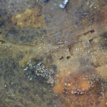
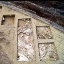
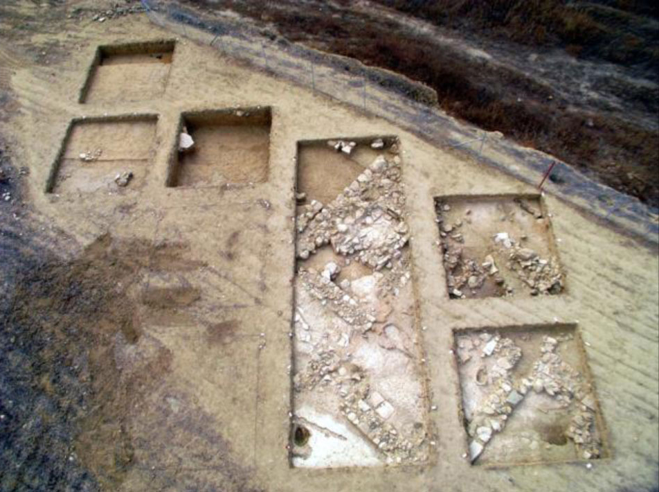
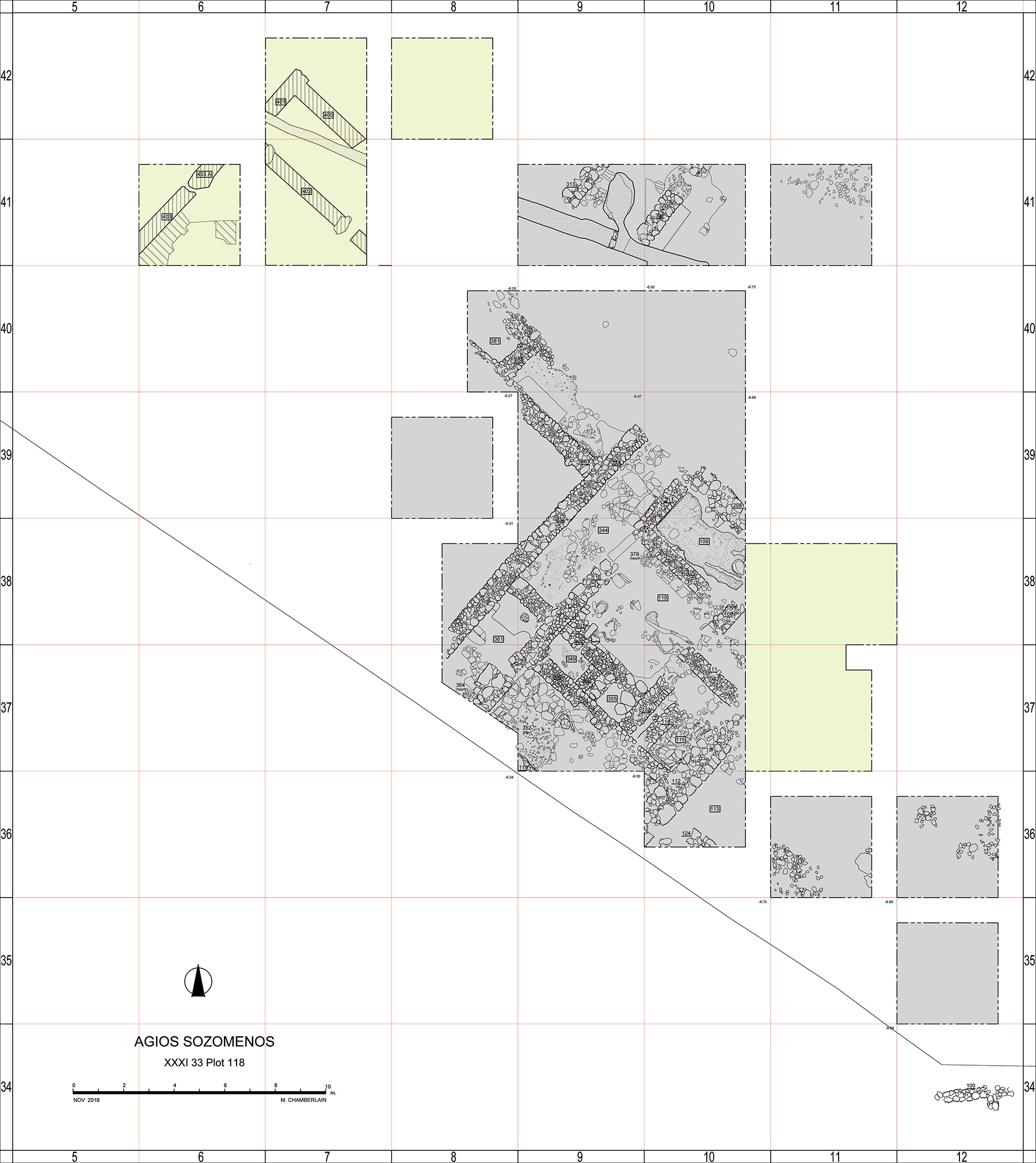
A rectilinear building in a NW-SE direction is being excavated over the last three years. Trenches were made this year on the eastern side of the building hoping to find the extension of the building. Unfortunately it seems to have been completely removed by deep cultivation (Trenches 37/11 and 38/11). However, the depression in the plaster floor of Room 109 was traced, a plastered cavity with a channel on its south side. A pithos sherd with parallel and wavy ridges was found in this area; a stone with some depressions placed vertically on the side of the depression, some ceramic slabs and a pithos sherd lined with plaster were found which may have been used to line its perimeter or cover it. The contents were sampled in the hope that they may yield some information about its possible use. A ceramic waster and a small diabase mortar were also found, confirming the evidence from previous seasons that ceramic production may have been one of the inhabitants’ activities. Further excavation in this direction yielded concentrations of stones and mortar but no surviving architecture. The ceramics associated with them were Plain Ware fragments of White Slip II, a Plain White storage jar with incised chevrons on the shoulder.
As no further remains were preserved, excavation continued on the basis of the geophysical survey, in the NW direction, where the corner of two walls could be observed (42/7); at the same time we avoided the areas interrupted by the irrigation channels of Medieval date which also interrupted the building’s fabric (Trenches 41/9 and 41/10). The extension of the long narrow wing found in previous excavations was found extending to the NW (Walls 401 and 402). A parallel wall to nos 212 and 312 (403 and 403A) confirms the geophysical survey and indicates that the building was rectilinear and extended towards the SW as well but was possibly eroded into the bank of the Alykos river tributary. The Medieval channel continued into this trench (42/7) in a similar direction to the walls and thus disrupted parts of Walls 400 and 401. Wall 400 is preserved to a height of ca. 66cm and about the same width. The adjoining wall 401 is only preserved to a height of 25cm and is ca. 62cm in width. Excavation in the interior of walls 400 and 401 consisted of the removal of a thick layer of white plaster and earth possibly representing the roof collapse and the mudbrick structure of the walls. A storage jar was found on the floor, possibly left in situ, near a hearth with a double clay wall in the corner of the walls 401 and 400. There may have been several storage jars or pithoi in this room, some decorated with relief ridges, judging by the number of sherds from different vessels. A large fragment from a lekane or “bath-tub” was also found, similar to the one found in the eastern part of the building. Another hearth was noted on the SE part of this long room.
An entrance was found in the SE part of Wall 402 which led into the next room delineated by Walls 402, 403 and 403a. Pithos sherds, Monochrome, White Slip I are the main ceramic types from this area as well as Red Slip and Black Slip, including a hybrid Black Slip/Red Polished IV bowl with impressed chain ornament.
Wall 402 is a well built wall with small stones and used stone tools and is narrower than the rest (52cm); it may have been originally constructed in Phase 1. Walls 400 and 401 may have been constructed later, which explains why the foundations of Wall 402 are much deeper. In the interior of the room the floor was made of a compact mixture of plaster. Fragments of the same pithos were found on both sides of the wall, in the fill on the south of the wall and on the floor of the long room. In the same way, a large stone quern was found in the wall possibly used as building material, the rest of which was found fallen in the debris on the south side of the wall.
In this area, on the south part of Wall 402, loose stones and compact brown earth may represent the wall collapse. A thick layer of compact brown and greenish soil below may represent the abandonment. Together with the gradual collapse of the structures, a thick layer of debris was created. Many pithos sherds with parallel ridges, charcoal and some animal bones and stone tools such as grinders, a stone axe and a pounder were found.
Below the doorway, a well-constructed stone drain was found, 13cm deep possibly belonging to Phase 1. A White Slip I sherd was found within its fill as well as some charcoal, small fragments of animal bone and a cupriferous stone (3797). The function of the drain will be clarified in next year’s excavation season.
Excavation continued in this area below the foundation level of Wall 402, where many loose stones (diabase) mixed with brown soil, greenish clay and some ochre on a compact whitish floor may perhaps represent an earlier phase. Fragments from a badly fired flat ceramic object, were noted on the floor.
Wall 403 was revealed, the continuation of Wall 401 to the SW, adjoined by a large heap of collapsed stones. Close to the wall, hard brown earth may represent the collapse of the mudbrick part of the wall; the rest of the trench further to the south, consisted of the same deep layer of compact brown and greenish soil found on the interior of Wall 402, the eastern side of the same room. Wall 403a may have been rebuilt in Phase 2 as larger stones were used on the top part, above a layer of soil.
On the exterior of the long narrow room formed by the two walls, a plaster floor was found with a large stone grinder in situ and a clay hearth. White Slip II sherds, Plain White ware, Black Slip and Red Slip and a burnt Monochrome bowl were amongst the finds as well as a stone grinder, possibly in situ. At the NE side of the trench, the floor, made of plaster, was set with pebbles. A storage jar with incised chevrons and sherds from a Base Ring jug were noted (3679).
On the NW of Wall 403a, the remains of a hearth were noted, several joining fragments of a large pithos with parallel ridges as well as one storage jar with an impressed string decoration on the shoulder. Another pithos was sunk in the floor in a shallow pit lined with small stones. In the same area some White Painted and Myceanaen sherds were found on the floor surface (3730).
Barsak
Excavation on the fortress of Barsak aimed at the investigation of particular questions such as: was there indeed a double wall as it was implicated in the aerial photographs? Were there internal subdivisions or was it simply a very sturdy enclosure? The team of Sturt Manning of Cornell University carried out a brief geophysical survey (GPR) and Dr. Zomenia Zomeni, geologist, pointed out some areas (-48/98) that might be more productive in answering the above questions. The first trenches of 5x2m were carried out in -46/95, -46/96 mainly to test the question of internal subdivisions. Soft brown soil was excavated with limited quantities of very small and worn Red and Black slip sherds and sparse, very worn Red Polished sherds; no architecture was revealed. Also trenches of 5x1m were excavated in -43/103, -43/104 and -43/105 with similar results. A trench of 5×2.5m was excavated in -48/98, again with similar results. No subdivisions were traced, either because they were ploughed away or because they did not exist. Another trench was excavated, perpendicular to the wall found last year (-43/99), which again, did not succeed in locating casemates, except for a huge scatter of stones from the wall itself.
Excavation continued with four more trenches of 1x1m (-70/97, -70/98, -70/99 and -70/100) at some distance to the north of the interior wall for the identification of a possible parallel wall. It was observed that in these trenches (-70/97 and 98) the bedrock was covered with plaster, as if to be used as a floor. In -70/100 an exterior wall was indeed found. Its construction differed from that of the interior wall, which was made of courses of large unworked stones. Instead, the natural bedrock was utilized on which stones were added with mortar to form an equally substantial wall. On the exterior of this outer wall, a deep trench was cut into the bedrock to form a huge ditch, the depth of which was not reached in this excavation season. Further trenches were excavated on the opposite side of the enclosure (the SE part of the plateau) to establish whether the exterior wall was present on other sides of the enclosure as well and not only on the north-west side, the most easily accessible part of the plateau. At a distance of about 15m. from the interior wall, the exterior wall was also traced, built of large boulders. Here also, the bedrock was cut to form a very deep ditch; again, the depth of the ditch could not be reached without extending the trench.
It is thus of particular importance that this year’s excavation have added considerable data to our knowledge on the nature of this structure. It was a massive fortification that must have needed sound organization for its construction. It was made of an interior wall of about 2m thick, an equally thick exterior wall and a ditch outside the exterior wall. It measured 230x230m and must have been quite visible, while it surveyed the entire area in all directions. The ceramics are limited in quantities and are very worn; they belong mostly to small vessels, and there seems to be an absence of storage jars, in contrast to Tzirpoulos at the foot of the plateau, where storage jars and pithoi are the most common pottery. Sherds consist mostly of Red Slip and Black Slip and no Plain White ware, indicating perhaps a short lifespan. On this year’s excavation evidence, it seems that Barsak was a robust structure that had nothing to do with production and storage and was only there for a short period of time, only partly overlapping with Tzirpoulos.
The survey
A pedestrian survey of the region was undertaken, with the goal of relocating previously identified Bronze Age sites and to better assess their geographical location, condition, and size, and to more accurately identify their chronological position and whenever possible, their function. Fourteen sites previously identified by the Cyprus Survey were relocated and recorded, five more are now believed to have been destroyed by modern development, and two previously unknown sites were recorded.
Following an initial survey and recording, seven sites were selected for more intensive and systematic survey and collection because of their significance and preservation. Notably, these include Ayios Sozomenos Glykia Vrysis, a site of small-scale excavation led by Einar Gjerstad in 1924, and Ayios Sozomenos Ambelia, originally recorded by Hector Catling in 1954.These two sites both proved to be significantly larger than previously believed, with surface finds and architecture from each settlement covering an area greater than 8 hectares. These sites, part of a dense and extensive pattern of settlement surrounding the Yialias River and the three large fortified sites on top of the plateau, support the identification of the Ayios Sozomenos region as an important economic and political centre at the beginning of the Late Bronze Age.