The structures, which date back to a period between the 1st and 6th century AD, were brought to light by ArcheoTest Srl during preventive archaeology investigations on behalf of Irisacqua srl and under the scientific direction of the Superintendency of Archaeology, Fine Arts and Landscape for Friuli Venezia Giulia. The study was therefore conducted in collaboration with the OGS, the “Augusto Righi” Department of Physics and Astronomy of the University of Bologna, and the INGV.
The relative rise in sea levels, a direct consequence of global warming, is one of the most studied phenomena by the scientific community and represents one of the most alarming environmental threats worldwide.
A new research, published in the journal “Scientific Reports”, which saw the involvement of scholars and researchers from the National Institute of Oceanography and Experimental Geophysics – OGS, of the Department of Physics and Astronomy “Augusto Righi” of the University of Bologna, National Institute of Geophysics and Volcanology – INGV and Superintendency of Archaeology, Fine Arts, and Landscape for Friuli Venezia Giulia, coordinated by Dario Gaddi of ArcheoTest srl, has uncovered three Roman and early medieval palisades in Grado (Friuli Venezia Giulia). The multidisciplinary analysis of these structures, which also served a protective function against coastal erosion in ancient times, has allowed us to reconstruct both the evolution of the Grado area’s depositional environment and the changes in relative sea level along the northeastern Adriatic coast. The evolution of the physiography of Grado and its lagoon occurred after the last glacial expansion (approximately 20000 years ago) and has been significantly influenced by human activity (the earliest evidence of human presence in Grado dates back to the 2nd century BC).
“Coastal areas are among the most vulnerable and are particularly at risk.”, explains Emiliano Gordini of the OGS, specifying that According to ISPRA reports, approximately 30% of Italy’s population lives in these areas, and according to estimates for the least critical climate scenario, sea levels could rise by approximately 0,5 meters by 2100. This trend, exacerbated by the increasing frequency of extreme weather events, risks causing profound morphological changes to the landscape and significant damage to infrastructure and settlements located near the coast.
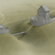
“Even in the past, sea level variations have had a significant impact on the occupation and distribution of human settlements in coastal areas.”, he adds Dario Gaddi of ArcheoTest Srl. Sometimes, changing environmental conditions have forced populations to permanently abandon sites threatened by flooding. In other cases, since prehistoric times, humans have responded with sometimes radical interventions in the natural environment, building defensive structures to counteract the ingress of water and preserve the habitability of the land. A prime example is Grado, a Roman port and lagoon settlement whose history is closely intertwined with two great Adriatic cities of the ancient world: Aquileia and Venice., explains the expert.
The investigations began with a preliminary assessment of archaeological interest for a public project commissioned by Irisacqua, which therefore funded all phases, from the preliminary risk assessment document, to the core sampling carried out in the area by Andreiα (Studio Associato per l’Archeologia delle Acque), to the on-site excavation conducted by ArcheoTest srl, to the laboratory analyses, based on the specifications and under the scientific direction of the Superintendency of Archaeology, Fine Arts and Landscape for Friuli Venezia Giulia.
“The multidisciplinary approach adopted for the study allowed us to obtain key information on the paleoenvironmental structure of the area, revealing how it appeared in Roman and medieval times, and to outline the effects of sea level variations in this sector of the northern Adriatic.”, explains Daniele Melini of the INGV. “Thanks to the surveys carried out, it was possible to develop numerical models relating to the influence that glacio-isostatic processes have had on sea level variations in the area over the last 5000 years. These then provided valuable support for the interpretation of the archaeological data, offering a more complete picture of the paleoenvironmental structure of the area.”
The palisades
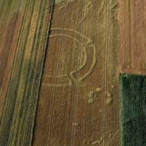
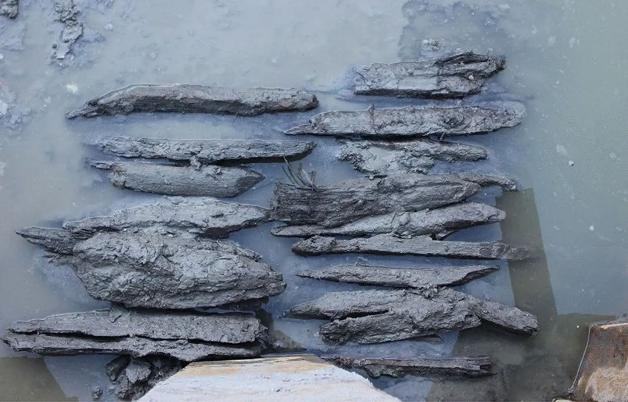
Numerous studies had highlighted, as early as the 1980s, how the archaeological remains discovered on the island and its lagoon, primarily from the Roman period, allowed estimates of relative sea level. The archaeological excavation carried out in 2021 near the Castrum of Grado led to the discovery of three palisades dating between the 1st and 6th centuries AD.
The oldest (1st-2nd century AD) was erected by inserting wooden planks into the sea to form a continuous barrier, the top of which is approximately 60 centimeters below current sea level. Their perfect state of preservation suggests that the planks were planted at the edge of the shore, in a mostly emerged area, to create a containment barrier for the reclamation material dumped from the mainland (including building debris and household waste such as stones, bricks, pottery, and food scraps). This debris is the result of a large-scale and prolonged reclamation and ground-raising operation along the coastal strip of the Grado settlement, dating from between the mid-1st and early 2nd century AD, when the sea level was approximately 1,2 meters (± 0,50 meters) lower than today. The palisade would later have been covered by lagoon sediments.
Another palisade, dated by dendrochronology to 566 AD, represents a probable attempt to stem the effects of rising sea levels. The wooden planks show clear signs of attack by the Teredo navalis, a microorganism that proliferates exclusively within permanently submerged wood. This proves a sea level rise of at least 40 centimeters and suggests that in the mid-sixth century, the sea level was between 80 and 90 centimeters lower than the current average.
Finally, there is trace of a third palisade, of similar age to the previous one, of which only three planks have been found. It was probably built not to mitigate marine incursion, but to consolidate the Castrum.