Historical Documentation
Prehistoric-Historic Times
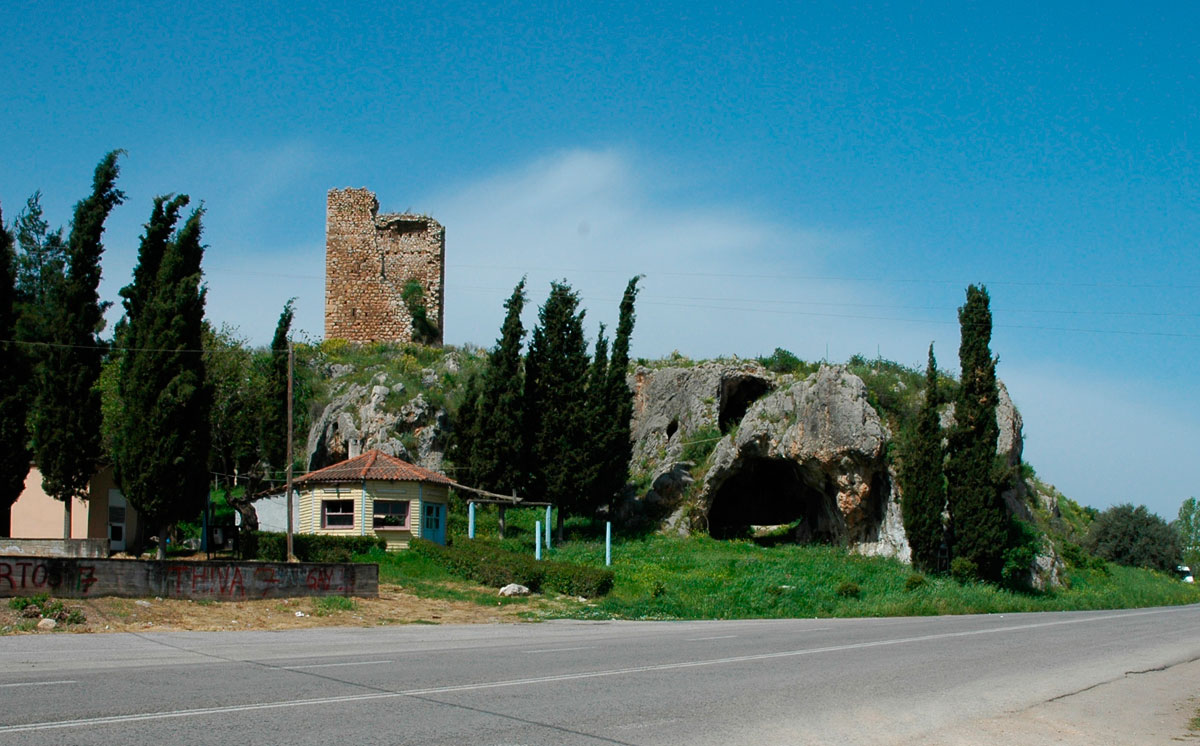
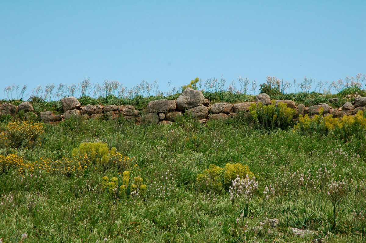
There is evidence of human settlement in the region of Aliartos prior to the Neolithic period, according to the dating of finds from two caves, the “Cave of the Tower” and the “Seydi Cave’’ (note 1), close to the eastern part of the town. Samples of organized types of habitation have, however, been found, diametrically opposite the caves on a hill, to the west of the today’s town. Excavations carried out by the British School of Archaeology in the 1930s brought to light finds that testify to the existence of a fortified citadel on the hill’s summit, already dating from the Mycenaean era (note 2).
Over the centuries, the ancient city of Aliartos grew and expanded on that same spot and was a strategically important pass (note 3) being situated between the lake of Copaida and the Elikonas mountain. Finds from excavations indicate that in historical times it was originally confined to the fortified citadel on the hill’s summit and that at the height of its powers it gradually expanded beyond the walls to the Lower City (note 4) on the slope near today’s network of roads. Excavations carried out on the hillside by the Archaeological Service brought to light a large number of graves and grave precincts that point towards the existence of an ancient cemetery (note 5) in the area.
Aliartos participated in the Onchestos amphictyonic league which centered round the sanctuary of Poseidon, by the same name, situated in the territory of Aliartos (note 6). It was also one of the cities of the original Boeotian Federation at the end of the 6th c. BC (note7). A milestone in its history was the battle of Boeotia in 395 BC, during which the Spartan troops besieging the city were defeated and their leader, general Lysander, was killed (note 8).
Two centuries later, in 171 BC, Aliartos was again besieged, this time by Roman troops which succeeded in invading and leveling the city (note 9). Two years later Aliartos is taken over by the Athenians, a fact confirmed by the “boundaries/landmarks” found in the area (note 10).
Middle Ages – Turkish Occupation
Finds dating from the Middle Byzantine Period were unearthed to the east of the ancient city, beneath modern Aliartos, affirming the existence of a settlement that subsequently develops into a extensive community and possibly into a town during the periods of the Frankish and Turkish Occupations (note 11). In regards to the latter period, information has been extracted from Ottoman archives in which the settlement appears by the name of Charmena (note 12) between 1466 and 1570.
A Chronicle of Copais
The drainage of lake Copais was a work that brought about the solution to a pair of important problems: that of malaria which afflicted the settlements round the lake and that of creating farm land to provide adequate food for the newly formed Greek state (note 14). As a result, there was already an interest in its implementation from the time of King Otto’s reign, with great efforts being made over the following decades for the project’s undertaking, which, however, failed to go ahead due to lack of necessary capital (note 15). In 1880, the “French Company for the Drainage and Farming of Lake Copais” was formed which, however, went bankrupt in 1887 (note 15). «Lake Copais Co Ltd», a company in which the English had vested interests, was formed that same year and chose the region of today’s town of Aliartos for creating premises which included farming and industrial units, buildings for administrative and financial services, housing for the staff, while also constructing a lightweight railway network (note 16). In 1953, the Greek state buys out the English company and expropriates both its premises and its mechanical equipment, whose ownership is then passed on to a new agency, still existing today, known as the Copais Organization, for the management of the land (note 17).
The Town Planning framework
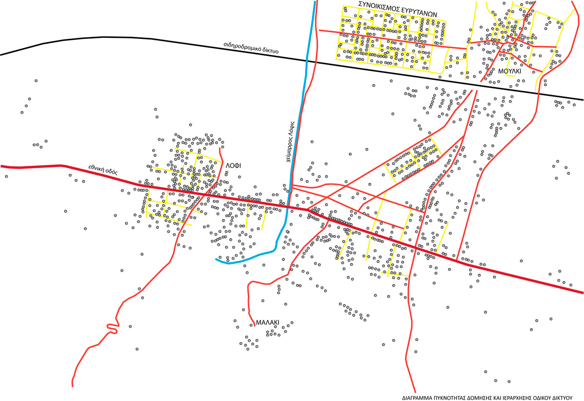
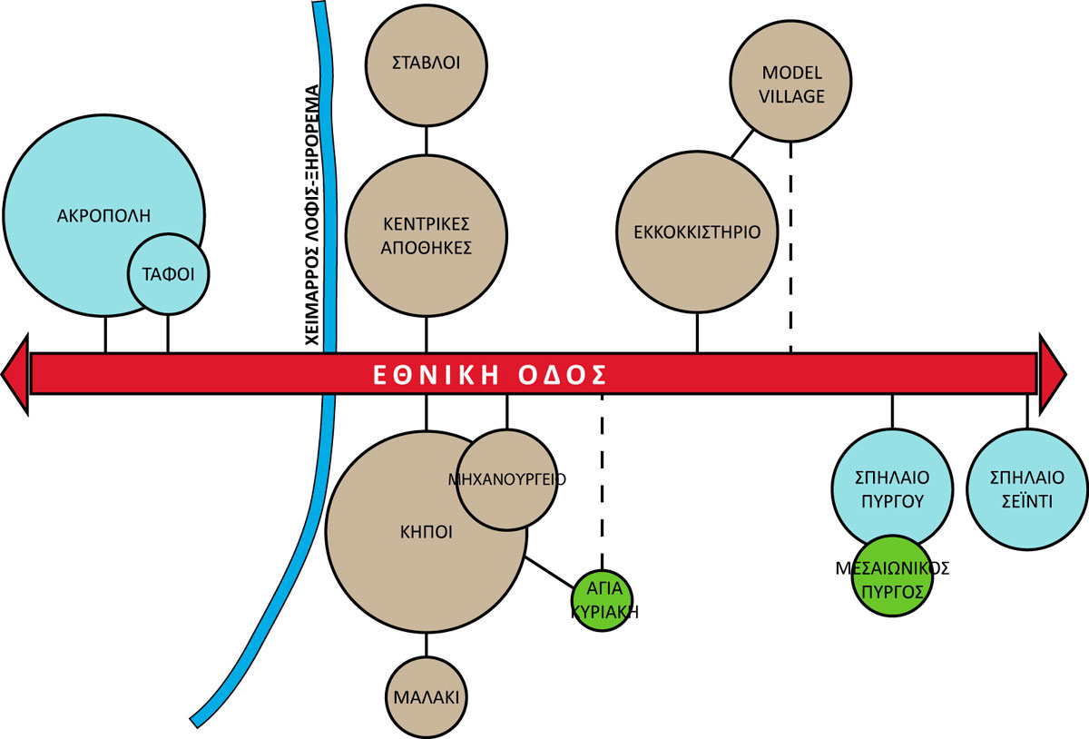
The urban network of Aliartos has a particular structure since it is not a single cluster of buildings but is composed, instead, of individual settlement cores linked by a network of roads and with the greatest building density (fig. 1). There are differences between the origins and consequently the forms of the specific cores, as some had existed prior to their being incorporated in the Aliartos community, others have resulted from the latter’s development following the English company settling in the area, while there are also settlements that are direct products of urban planning.
The Moulki settlement, existing prior to the English company’s arrival in the area, is to the north of the railway tracks and has a radial form of network with a densely built up core. In 1977, the Settlement of the Eurytanians was created to the west of Moulki, so as to house the inhabitants of the mountainous district of Eurytania stricken by landslides. The network’s structure in the specific quarter stands out as it follows the layout of roads according to the Hippodamus system. Both quarters are cut off from the rest of the town mainly because of the strong boundary to the south made by the railway line. The equally isolated Malaki quarter which started to develop on the hill, south of the town, in 1960, is not part of the urban street planning and consists, for the most part, of buildings used for second homes (note 18). The Lofi quarter makes up the town’s western sector, borders with the archaeological site of the ancient town’s hill and spreads on either side of the main road. Lastly, the eastern sector is jointly made up of the land which belonged originally to the English company and was then granted to public agencies, combined with the town’s urban expansion to the south and east reaching the boundaries of the urban street planning. It includes the premises of the English company and of the Copais Organization both attracting the start of new activities and new housing thus contributing to the town developing its present appearance. The town’s fabric also includes a strong axis, namely the main road that crosses the town from east to west and connects Thebes to Livadia at a local level and Athens to Delphi at a national level along with the urban centres of Phokis and east Boeotia. Construction is considerably dense along this roadway and both trading and administrative functions are highly concentrated here, alongside the use of housing. Another essential axis is the Lofis torrent which vertically intersects the main road and forms an important geographic boundary between the east and west sectors of the town.
Monuments
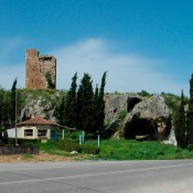
The evolution of settlements in the region of Aliartos can be witnessed in the remains of buildings dating from periods that have survived in the area. The two caves to the east of the town (fig. 2) combined with the surviving Mycenaean fortifications at the hill’s summit to the west (fig. 3) are sites of the prehistoric era. The hill of the ancient city along with the cemetery to the southeast is likewise a site of the classical period. Surviving remains from the Medieval period include the Tower over the cave with the same name, at the town entrance (fig. 2) and the ruins of the church of St Kyriake near the so called “Gardens’’.
As for later monuments, these are namely the surviving buildings of the premises of the English company for the drainage of Copais, which were declared listed buildings in 1991 (note 19) and they include:
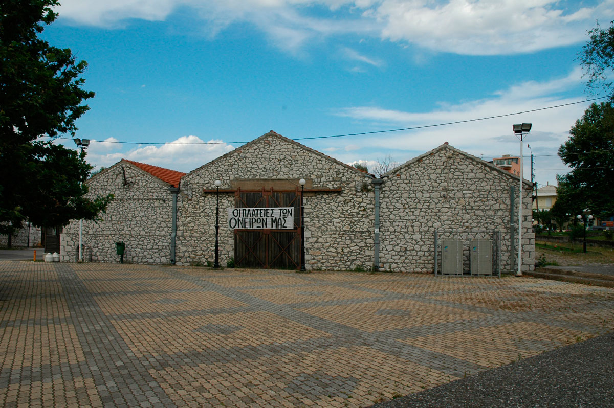
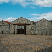
a) A Group of Granaries situated in the main square. The buildings have been granted to the Municipality of Aliartos which went ahead with their restoration and use (fig. 4).
b) A badly preserved Group of Stables, to the north of the main square, with certain of its houses in use.
c) A Group of Workshops for Engine Repairs, opposite the main square, which continues to house operations of the Copais Organization.
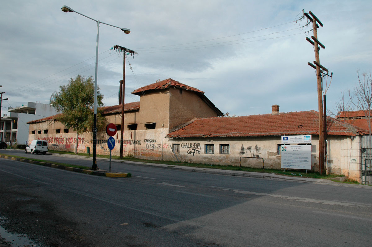
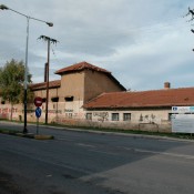
d) A Cotton Mill, to the east of the above buildings and constructed later. It was intended to house the “Museum of Rural Heritage and Agricultural Technology” which, however, has not been implemented (fig. 5).
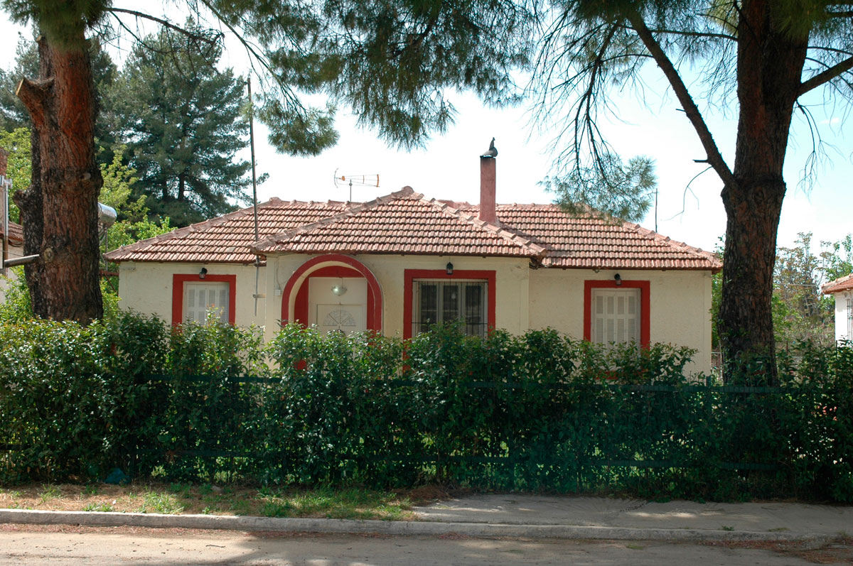
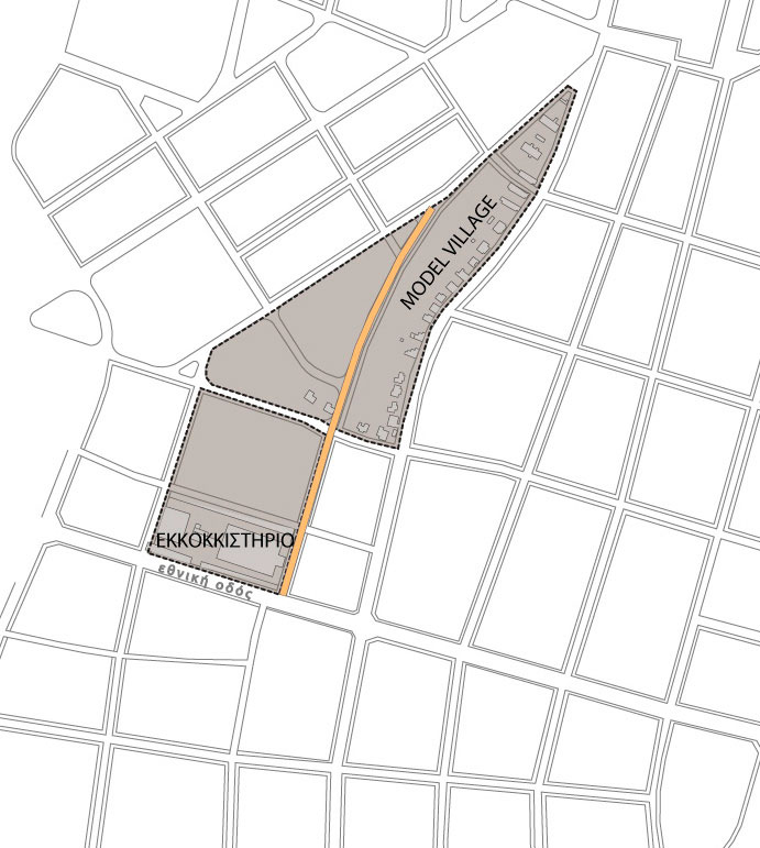
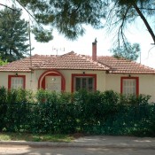
e) A Model Village Settlement, north of the cotton mill, which includes simply designed one storey houses for the staff, lined up along the local road (fig. 6). They have been in use till now, rented out by the Copais Organization and the Aliartos Municipality who has been granted most of them.
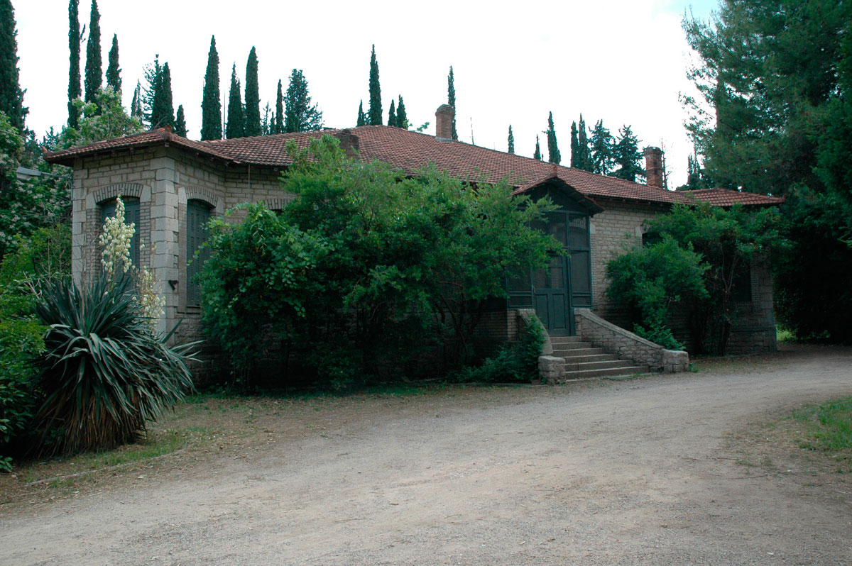
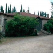
f) A Group of Gardens, spread out along the east bank of the Lofi torrent, south of the Workshop for Engine Repairs and the main square. It is the company’s largest building complex and is noted for the particular morphological features of most of its buildings and its rich natural surroundings. It includes the Administration Building, the house of the General Manager (fig. 7), houses of company executives and staff, garages and storerooms. The Administration Building is now home to the operations of the Copais Organization, while the houses are privately rented. The General Manager’s house and the garages do not currently serve any purpose.
On the Garden Complex’s southern boundaries are two surviving water mills, while even further south, on the northern slope of the Malaki hill, there are two more surviving residential buildings.
A Management Proposal
The value of preserving the architectural heritage in the Aliartos region as well as its importance to the specific town is made clear by the survey of its remains. When this is combined with an analysis of factors and conditions which today make up the region’s urban environment, the formulating of an overall management plan becomes worthwhile. The ultimate goal will be to put the remains to good use so the region can become a cultural node directly connected with the history and culture of the Copais Basin. The targets for the realization of this objective should be the following:
1. The unification of the monuments’ scattered remains for them to be treated as a single group within the town’s structure and their coordinated public management to be made possible.
2. Their incorporation in today’s urban environment at a town planning level, by redefining the layout of the city. The incorporation both of new functions as well as the social environment by approaching the local community and encouraging its awareness.
3. The conservation and protection both of the monuments and their values by special procedures for their preservation, the organizing of collections of the accompanying archive material and, lastly, the promotion and enhancement of the monuments.
The management of the town’s wealth of monuments at an urban planning level, requires the collaboration of all the stakeholders involved and the participation of the local authorities. It is proposed that, for this purpose, the Municipality of Aliartos establish a committee for the management of monuments which can be joined by representatives from stakeholders for the protection of individual remains. The granting to the Municipality of listed buildings still managed by the Copais Organization is also considered important, so these can come under a single ownership and constitute a self sufficient group of monuments where a single policy for interventions can be applied.
At the same time it is imperative to take action for their protection at an urban planning level, by establishing special building conditions. These will aim at preserving the scale of the urban landscape, the building density and above all at avoiding competition between new constructions and groups of monuments. The aim must not be to copy past or existing forms but to produce new, good quality architecture that will respect the features of the urban landscape. The special building conditions will not be applied in a uniform manner throughout the city but will be distinguished in zones.
It is also required to set clear boundaries for the cultural nuclei making up the individual monuments. This will distinguish the regions where planning will take place and where the previously mentioned measures for their protection will be realized (fig. 8). This way a clear picture will emerge of the manner the groups of monuments are arranged within the town’s grid and their relation to basic axes, such as the main road and the torrent of Lofis. Moreover, their grouping becomes possible for them to be tackled later at a town planning level.
In order to achieve the integration of the historical buildings’ remains with the town’s modern environment, it is necessary to redesign the existing urban plan by redefining the way the monument remains relate to it. Regarding the sites outside the city limits, the proposed interventions include:
a) The Caves: landscaping and the addition of inconspicuous urban elements, blending with the natural environment, for the caves to become stopping places of cultural interest. The medieval tower’s integration with the landscaping over the cave and the creation of an observatory. It is essential to create access to the Seydi cave from the main road as is the addition of sign posts for both caves.
b) The Hill of the ancient city and the Cemetery: the first step is to clearly set the region’s boundaries so that the site can become more easily recognizable. Landscaping and the layout of paths are suggested as well as the addition of inconspicuous outdoor equipment including the necessary installation of signposts. The incorporation of the cemetery site to the east is also considered essential for the enhancement of the ancient topography. The aim of this procedure is to create an archaeological park that will be included in the network of the town’s open spaces.
The procedures proposed for the monuments within the urban fabric, focus on creating two cultural “zones”:
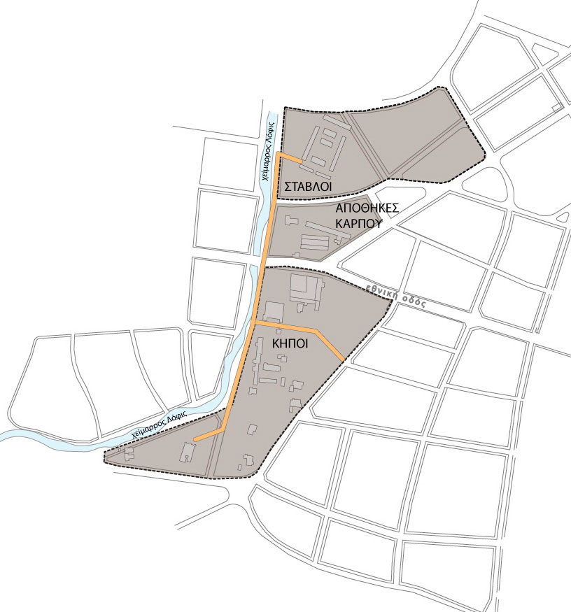
a) A “zone” on the banks of the Lofi torrent: This includes the Stables, the buildings in the main square, the Workshop for engine repairs, the buildings of the Gardens and the Watermills. The zone’s central location, the area it covers and its pronounced monumental character are suitable for interventions that will render it a type of “historical centre” for the town, where most of the material evidence will be gathered from the operations of the drainage company and the Copais Organization.
The aim of the proposed intervention is to unify the separate urban complexes through their relation with the axis of the Lofis torrent (fig. 9). The restoration and landscaping of the torrent’s east bank is proposed and the layout of a path parallel to it which will link each individual urban complex and blend with the urban landscape. The path will branch out in the direction of the individual groups of buildings in the cultural zone as well as extending as far as the Malaki hill to link the listed buildings in that area. It is essential to add outdoor equipment for the creation of stopping places as well as the installation of signposts.
b) Cotton Mill “zone”: This includes the Cotton Mill Complex and the Model Village settlement to its northeast.
The intervention’s aim is the redefinition of the urban layout plan to achieve the unification and enhancement of the monuments that make up this particular “zone”. Restoration of the main street is proposed, along which the houses of the “Model Village” are situated, as well as the pedestrianization of the road which forms the western boundary of the urban block (fig. 10). The pedestrian walk will reunite the two cut off houses at the southeast end and will link the settlement with the “Cotton Mill” complex. This intervention will create a central axis for correspondence and circulation in the specific cultural zone, directly referring to the main street and the use of the Cotton Mill as a museum. The creation of parks is proposed in open spaces which will be incorporated with the zone as well as the placing of signposts at key points.
It is essential to redefine existing uses and incorporate new ones with the (buildings’) empty shells, so as to achieve the conservation of the monument remains and, moreover, to integrate them with today’s urban environment at an urban planning and social level.
It is proposed to use the listed buildings of the “Model Village” settlement as houses, as well as the buildings of the Malaki hill and the water mill to the southeast of the “Gardens”. The existing practice of leasing them to private individuals can be maintained provided they are used exclusively as residences. Preserving their original use which is directly linked with their typology, will be achieved in this way and economic resources will be secured for the overall administrative and managerial plan.
The “Cotton Mill” complex is already intended to house on its premises the “Museum of Rural Heritage and Agricultural Technology”. This specific use will elevate the complex’s status to becoming a significant hub of cultural activities for the city and will contribute to the preservation and enhancement both of this particular monument’s value and of the wider cultural zone to which it belongs.
The “Residence of the General Manager” situated within the “Gardens” complex is considered appropriate for use as a museum/exhibition space. Specifically, its particular morphology combined with the surrounding landscape, render it one of the most important monuments both of this particular reserve of history, but also of the town’s architecture in general. It’s housing of the historical archives of the Copais Organization combined with its interior’s conversion into an exhibition space, will contribute to linking the monument remains with the town’s history and the Copais region while serving as a significant hub of cultural activities
Certain listed buildings in the main square have been chosen for cultural uses. Their key positions within the urban fabric and their direct connection with the town’s main communal space make the buildings suitable for cultural, educational and municipal functions.
It therefore seems appropriate for existing functions to be maintained and the new ones included in the future to belong to the above categories. In the instance of the Organization’s relocation or liquidation, the same applies to the following buildings: those where the functions of the Copais Organization are housed today, the “Administration Building”, the “Gardens” and the “Group of Workshops for Engine Repairs”.
In the case of the “Gardens”, excluding the “Residence of the General Manager”, it is proposed that the rest of the buildings house a municipal Old Peoples’ Home. In this way, the Municipality will be in charge of their joint management and protection as a whole, while, in a sense, preserving the residence’s original use.
Lastly, the “Stables” complex offers itself for use as a Stud farm which will allow for growth both of the economy and tourism. Its leasing to a company for its development will be an important business investment with financial benefits to both stakeholders and the local community. On the other hand this particular use is directly linked to the historical function of the complex and offers the possibility of organizing not only athletic but also cultural activities. Combined with a riding club, it can become the starting point for organizing cultural excursions on horseback in the wider district of Copais. In this way, it will offer the town opportunities for sustainable development in accordance with the region’s rural character, linking it both to its historical past and directly to its natural environment.
Demetra Manglaras
Architect, Engineer
Postgraduate in Monument Management