A University of Kansas researcher has spent years studying “aquaterra” — his term for regions around the world once populated by ancient humans that today are submerged under water due to sea-level changes.
Jerome Dobson, KU professor emeritus of geography, believes these regions — typically extending from continental coasts and surrounding scattered islands — contain vast archaeological treasures and answers about ancient humanity, and deserve much more research attention.
Dobson and Italian colleagues Giorgio Spada of the University of Bologna and Gaia Galassi of the University of Urbino recently published a reexamination of ancient human migratory routes from Africa, where homo sapiens first evolved, based on a newly improved glacial isostatic adjustment (GIA) model of historical sea levels along with DNA and archaeological data.
An improved simulation of ancient sea levels can reveal how melting glaciers — continuing long after the Last Glacial Maximum — may have transformed migration pathways and shaped the rise of civilizations in Africa.
The new research appears in the peer-reviewed journal Comptes Rendus Géoscience, published by the Académie des sciences, heir to the Comptes Rendus des Séances hebdomadaires de l’Académie des Sciences, founded in 1835 by Arago.
“The exciting implication is that a lot of underwater landscapes have archaeological relevance, and this mapping gives scientists a better shot at finding them,” Dobson said. “We hope this enables people to see and explore the landscapes that were exposed during the last ice age — especially at the Last Glacial Maximum 21,000 years ago.”
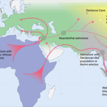
Dobson’s study refines understanding of ocean levels, coastlines and ancient migratory corridors in Africa and West Asia, using the new sea-level data to explore alternative land and sea routes into and out of Africa. These include the Suez crossing between the Red and Mediterranean seas, the Gulf of Aqaba route to the Levant, the Bab el Mandab crossing to Saudi Arabia, the crossing from Foul Bay to the Mediterranean Sea, and the island route across the Sicily and Messina straits.
“We wanted to generate coastlines that are physically and geophysically correct,” said the KU researcher. “Researchers need to use GIA modeling because simply subtracting sea-level height from topography isn’t enough. The Earth’s crust literally warps under the weight of ice sheets.”
According to the findings, some of these important migration routes were exposed by retreating seas for much longer than was known previously, though they varied with regional sea-level fluctuations.
Dobson and his co-authors also used datasets of DNA to reconstruct how human beings migrated out of Africa — seeing where they align with possible geographical routes.
“We benefited from a newly published map of DNA centers going back 2 million years,” Dobson said. “It shows a single ancient origin in the south, near Meroe in Kush, well into Africa. The archaeological evidence is sparse, while the DNA evidence is strong and consistent.”
The team sought to trace early human migration from the first-known centers of humanity. They examined northern routes through the Sinai Peninsula and southern routes that cross the Red Sea at the Bab el-Mandeb.
“The early human haplotype center appears to be in northeast Sudan,” Dobson said. “That wasn’t a shock, somewhat expected by the DNA experts who discovered it. There were clear connections going up into the Levant. Archaeological literature often emphasizes the southern route across the Bab el-Mandeb, but the maps they produce show little connection between the western and eastern sides of that divide.”
Dobson said that although the Bab el-Mandeb is the narrowest passage geographically, it might have been a major barrier depending on the watercraft of that time.
“People who study this deeply say the northern route — through the Sinai — is well established,” said the KU researcher. “The southern one, across Bab el-Mandeb, looks much less supported by archaeology based on the new data.”
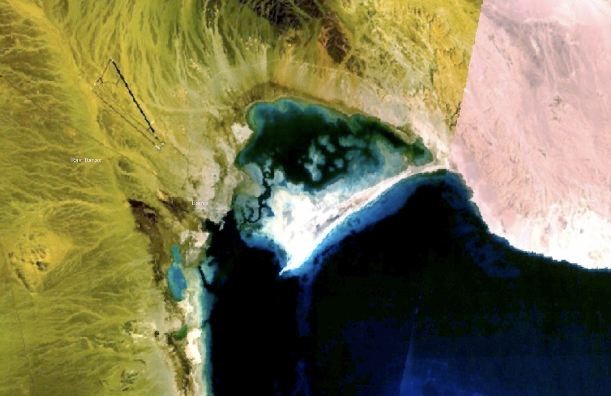
Dobson and his co-authors considered other migratory routes and crossings. Their findings show south-to-north and east-to-west directions of human occupancy in the Nile Valley and highlight the site of Berenice on Foul Bay along the Egyptian coast of the Red Sea as a port or potential point of crossing.
“Two things make Foul Bay important: First, it’s an alternative route when sea level is low,” Dobson said. “The Isthmus of Suez is over 500 kilometers across — such a long, dry crossing. We expected people would prefer going up through Foul Bay to the First Cataract of the Nile, which would only be a 300-kilometer route. Even in favorable times, people are concerned with long north-south voyages on the Red Sea, which is narrow and has tremendous coral reefs, especially on the western side. Foul Bay would be an important alternative for anyone going from the Red Sea to the Mediterranean or vice versa.”
The KU researcher asserts that with the new information about Berenice, people should reexamine migration into the Nile Valley before or during the glacial maximum. Coral reefs near Foul Bay might hold more clues, according to Dobson.
“It is well established that coral reefs, including patch coral reefs, are dependent on a solid base,” he said. “Our circumstantial evidence is intriguing, but it demands confirmation through rigorous searches for evidence of human construction.”
Because the GIA data developed by the research team is open access, it can serve future research in disciplines like geography, archaeology, migration studies, climate-change science and species conservation.
“This is a community resource,” Dobson said. “We wanted to put these reconstructions in investigators’ hands so they can explore their own regions of interest — where humans lived, what the land looked like, and how it changed.”