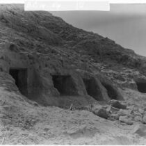
The Boila site lies on the east bank of the Voidomatis river, exactly on the western entry to the valley, at an altitude of approximately 500 m. Facing the North and situated on the banks of a stream on an Eocenian limestone layer, it appears today as an elongated shallow rock shelter (max. dim. 17 Χ 5 m.); however, geological observations led to the conclusion that it had been better protected in the past, since its natural protection gradually receded due to erosion and tectonic incidents. Its overall stratigraphic sequence belongs to the late Upper Palaeolithic period and to the so-called Epigravettian cultural phase.
The Palaeolithic research in Boila in the Voidomatis valley, loannina district
20 Aug 2012
by Archaeology Newsroom
- A
- A
- A