Archaeological documentation and evaluation
Historical Data
From antiquity to the resettlement at Palaiochora: Interest had been shown in Palaiochora from antiquity, when the ancient town of “Oie” was located on that exact spot. Building activities, using old and new materials, carried on into the early Christian era (5th-9th century AD). The ancient town of Aegina was gradually abandoned in the 9th century, around 896 AD (note 1), because of raids by pirates (Saracens and Arabs). The island’s capital was transferred inland, for approximately 1000 years, till 1800.
Frankish rule and Catalan sovereignty (1204-1451): After the Fourth Crusade, Aegina was occupied by the Venetians, followed in 1317 by the Catalans with Alfonso Fadrigo of Aragon as governor. The island will remain under Catalan rule till 1451.
The first period of Venetian rule (1451-1540): In 1462 the Castle of Palaiochora was fortified with money given by the Venetians to the people of Aegina in exchange for the sacred skull of St George which was kept in the church of Panagia Foritissa in the settlement’s “foro”. In 1502, Turks, led by Kemal Reis’in, attacked Palaiochora, destroyed its Castle and captured 2,000 inhabitants. In 1537, Hayreddin Barbarossa laid siege to the Castle of Palaiochora and destroyed the town capturing 6,000 inhabitants and leaving only the churches untouched. Palaiochora came under Turkish rule.
The first period of Turkish rule (1540-1687): In 1654, the Venetian Francesco Morosini bombed the town of Palaiochora and captured between 300 to 800 people of Aegina. The island’s decline was brought about by constant hostilities between Venetians and Turks, by the lack of men and by poverty. Finally Aegina was handed over to the Venetians.
The second period of Venetian rule (1687-1715): In 1687 Morosini repaired the ancient commercial port and the Castle of Palaiochora. At the same time there was also a population growth.
The second period of Turkish rule (1715- 1821): Venetian rule ended without any resistance on the part of the islanders and Aegina was taken over by the Turks. Gradually and free of the fear of pirates, the coastal town of Aegina developed once again and Palaiochora was finally abandoned.
Archaeological data
The monuments on the site of Palaiochora
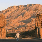
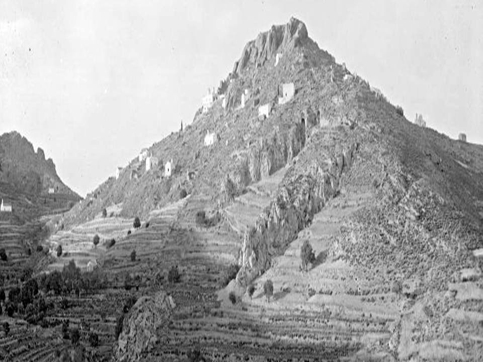
The Castle is located on the hill’s summit while the rest of the settlement is shaped like an amphitheatre following the contours of the hill’s incline (fig. 1). Habitation was dense because of a preference for the settlement’s southern, eastern and western sides. The northern side was obviously not a choice as it offered an unobstructed view of the port of Souvala, making Palaiochora a target for pirates. The rocky aspect of the hill wished to be maintained by the inhabitants also by the choice of materials for the building of their houses so as to further protect the settlement.
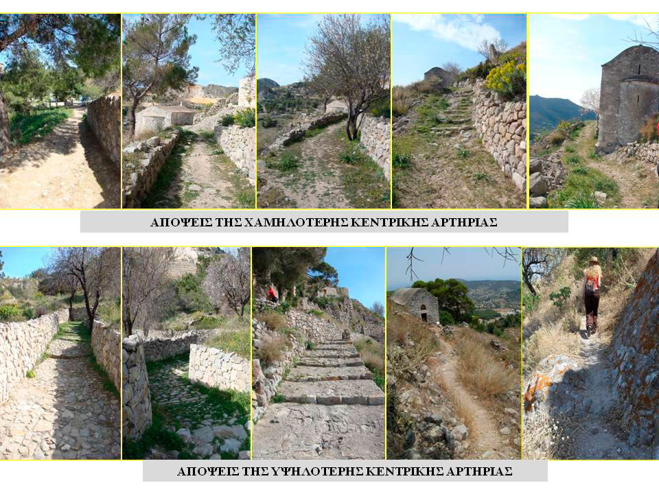
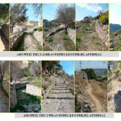
The existing urban grid of the medieval settlement: Palaiochora’s urban grid consists of two big concentric main arteries which come as large footpaths almost running in parallel to each other, which are interrupted in places by narrower paths, vertical to them. Gates (note 2) were formed at the meeting point of the horizontal and vertical axes. The position of the transverse footpaths was determined by the flanking walls of the various buildings which followed the same arrangement as the contours, reaching as high as the hill which was the starting point of the Castle’s natural fortifications. Morphologically the paths resembled those with cobblestones with a paving of stone slabs (fig. 2).
Fortifications and secular architecture: Two main parallel road arteries ran along at least two of Palaiochora’s surrounding walls, which incorporated the walls of churches and private houses, thus substituting the fortifications. The masonry of the private houses was for defence uses because it formed the transverse paths while acting as transverse walls if the bottom peripheral walls were disrupted. This fact can be proved by the ruins on the lower part of the church of the Aghioi Anargyroi. To the North West of the town there are no ruins proving the existence of fortifications on that particular spot, possibly because of the particularly steep terrain that does not allow for them. The houses were rectangular, small and built of rough local stone using mortar as a binder, while they were coated with plaster on the outside.
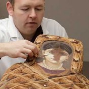
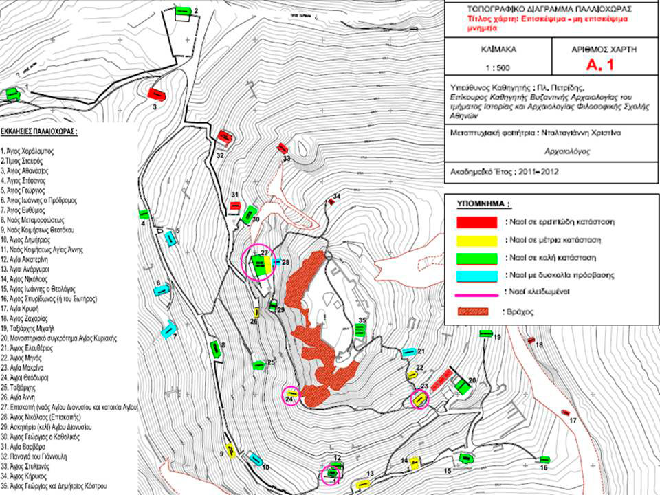
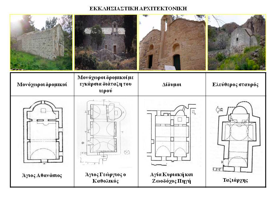
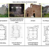
Church architecture: During the Byzantine era, Aegina constituted an independent Archbishopric which was a definitive factor in the great church building activity in Palaiochora (note 3). Today there are 35 churches, although according to tradition, there were 365, one for each day of the year. They extend all round the Castle’s perimeter, to the east, west and south of the settlement hill and can be seen from the main road that starts from the port of Aegina. The surviving churches are preserved in relatively good condition (fig. 3). They do not, however, belong to the same architectural type (note 4) but to the following four: single-aisled (notes 5, 6) (23 churches), single-aisled with transversal sanctuary (3 churches), double (5 churches), cruciform (2 churches). The church of the Bishopric is an exception that does not belong to any type (fig. 4).
An analysis of the value of the monuments in the settlement of Palaiochora
When evaluating the importance of the medieval settlement of Palaiochora we highlighted the following values to be found in the monuments: a) Scientific value: It promotes knowledge in a variety of fields (Architecture, Epigraphics, Preservation-Restoration), b) Historical and Archaeological Value: For a 1000 years it was the island’s medieval capital, c) Value as a Unique monument: It is the “necropolis of the Saronic gulf” and its only medieval settlement, d) Architectural value: Combines four types of architecture, e) Artistic-aesthetic value: It has rare wall paintings of the post byzantine period, f) Educational value: Ideal for touring and sightseeing, f) Social value: To the locals who perceive the region’s historical continuity.
The recognition and assessment of risk in the administration of the archaeological site
Risk was ranked in three categories and for each of these, a corresponding technique of management was proposed. We will briefly refer to specific risks in each category.
Large scale risks: The danger of fire during the summer months, the difficulty of managing vegetation and roots, possible adverse weather conditions during the winter, possible discovery of unsafe floors, crumbling sections of masonry, possible discovery of new wall paintings.
Medium scale risks: Possible discovery of a cemetery, difficulty in moving about on higher ground, earthquake possibilities.
Small scale risks: Possible delay in the initial funding of the project, a possible landslide due to loose terrain, difficulty in transporting screed material to the site, difficulty in removing debris, difficulty in acquiring expert technicians to oversee the work in situ, difficulty in acquiring an expert finance employee.
A plan for the management and enhancement of the site
SWOT Analysis
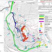
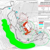
The use of the SWOT analysis (Strengths, Weaknesses, Opportunities, Threats) as a tool of methodology was important because it enabled us to set up a Master plan which has a structure divided into the following three areas: protection, documentation-research and enhancement. These are our three strategic targets regarding the medieval settlement of Palaiochora. The achievement of these goals enhances the value of the monuments that make up the settlement, establishing it as a perfectly functioning archaeological site of our times, accessible to visitors and the locals of Aegina (fig. 5).
In the area of protection it is of primary importance to set up a legal framework clearly defining the boundaries of the settlement, while also referring to the Protection Zones, that should strictly accompany it. Moreover, operations for stabilizing and restoring the secular and church architecture as well as the fortifications should be undertaken immediately because of their bad state of preservation (fig. 6).
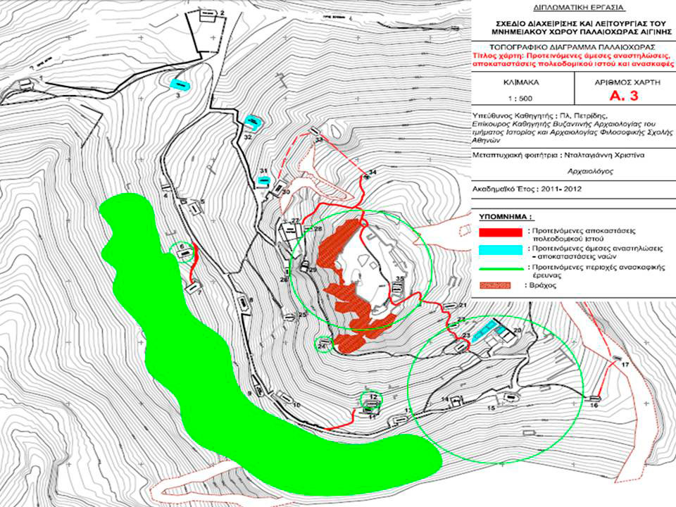
Regarding the field of research-documentation, it is necessary to conduct rescue excavations as well as excavation trenches to improve the picture we have of Palaiochora in terms of its material remains. At the same time we need to complete with new research and data the existing available bibliography on the settlement. It is therefore essential to create a digital archive.
There is great potential in the area of enhancement as long as the economic resources are ensured for the implementation of all the goals which are presented here in brief. Initially the urban grid of Palaiochora must be shaped and enhanced as well as the determining of primary and secondary routes for touring the site. The site must also acquire an infrastructure including a museum, a cafeteria and restrooms. The adequate lighting of both the monuments themselves and the whole of the archaeological site, constitutes an element of enhancement. Finally, a definitive factor in achieving the site’s up grading is the proper information given to visitors and the local community as well as the ensuring of Palaiochora’s connection with the island’s centre (fig. 7).
It is worth noting that any effort of enhancement should follow the principles determined by the International Charters for the protection of monuments (note 7), but also the legal framework of the country where the site to be up graded is situated. In the case of Palaiochora, all restoration work will be guided by the principle of reversibility, namely the possibility of the monument being returned to its original state, with a clear discrimination made between old and new material. In this manner we respect the historical phases of the monuments without putting any strain on them, while, at the same time, preventing the misinformation of visitors and of future scholars.
Excavations
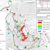
In 1537, on the eve of Barbarossa’s raid, the population of Palaiochora amounted to 9,000 inhabitants. Today, however, there is no indication of the cemetery’s location and moreover its existence is not documented in bibliographies. It is, therefore, a paradox that a settlement with such an age-old history should not have a cemetery or, more correctly, that this should not have been located till now. This is why it is recommended that, initially, an extended surface survey be carried out, followed by an excavation survey all along the wall’s perimeter. The latter stretches below the following churches: Aghios Stephanos, Aghios Ioannis Prodromos, Aghios Euthymios, the church of the Metamorphosis, The church of the Virgin’s Dormition, The Aghioi Anargyri, Aghios Ioannis Theologos up to the convent of St Aikaterini which is next to Palaiochora. It is a large area with a gentle incline ending in a plain. Apart from the possible discovery of a cemetery, an excavation in this district will help us find clear boundaries of the settlement or else fortification works as well as remains of secular architecture (fig. 6). The church of Aghia Kyriake is an exception, where in 2003 its restoration was preceded by an excavation survey. Regarding the urban grid in this spot, we would suggest repairing the destroyed footpaths so as to restore communication between the churches by the two central road arteries and the transverse paths.
The area stretching to the east of the Castle is rocky and particularly steep while it is also directly visible from the port of Souvala, therefore, construction work was avoided on that side so as to protect the settlement from pirates. Nevertheless, Ancient Oie was built on the side of the Castle. An excavation on this spot would help provide evidence for this point of view. Quite a few architectural members have, in fact, been used a second time either as lintels or as spoils/spolia (re-use of earlier building materials) in churches of Palaiochora,while some are also kept in the storerooms of the 1st Ephorate of Byzantine Antiquities. These are all however only indications and need systematic research and excavations.
Finally, in three churches of Palaiochora, according to sources of bibliography, we encounter certain elements that either suggest the existence of an earlier church, or they help us in the dating, a fact that has to be confirmed by excavations. These are, namely, the churches of Aghios Ioannis Prodromos, Aghia Aikaterini and the Aghioi Theodoroi.
Visitors’ routes
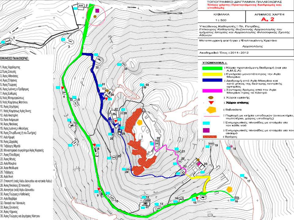
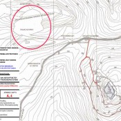
Palaiochora occupies a large area in which we can distinguish two main paths. It is advisable to suggest a route for the visitors so as to make it easier for them to fully understand the way the site operates and the connection between the monuments. The plan therefore provides a main route, two supplementary ones and one for treks and nature lovers (fig. 5). To be precise, the proposed main route will start, next to the main entrance, at the church of the Holy Cross (Timios Stavros) and will follow the lower main path. Along this route, the visitor will encounter the churches of Aghios Athanasios, Aghios Stephanos and the church of Aghios Georgios on his left. Then, on the right, he will encounter the churches of Aghios Ioannis Prodromos, Aghios Euthymios, the Metamorfosis and the church of the Virgin’s Dormition (Koimisis Theotokou) opposite the church of Aghios Demetrios.
Next along this route are the churches of the Aghioi Anargyroi, Aghios Nikolaos and Aghios Ioannis Theologos. The route finishes at the church of Aghios Spyridon. It is worth mentioning that for the duration of this route the visitor will obtain information both from supervisory material supplied at the entrance of the archaeological site and from many information boards to be described in detail further on. One of the enhancement plan’s concerns is that the site should be accessible to disabled people which is possible due to the main route’s low gradient not exceeding 5 to 10 degrees. The path’s layout will be realized according to the suggestions made by the architect/ civil engineer who will take into consideration all the parameters and will secure the visitors’ safe circulation.
Regarding the other two suggested routes, after the two convents of Aghia Kyriake and Aghia Makrina, the path branches out offering the visitor two choices: the first is to continue his course towards the castle where the twin churches of Aghios Menas and Aghios Eleutherios are to be found. His second choice is to follow the main path that is higher up and almost parallel to the lower one , ending up at the complex of the Episkope ,having passed by the churches of the Aghioi Theodoroi, the Taxiarchis and Aghia Anne. At the Episkope we encounter the church of Aghios Nicholaos and the monk’s cell of Aghios Dionysios. Our route does not stop however, but continues and leads to the main square with the church of Aghios Georgios Katholikos, Aghia Varvara, it then passes by the church of Panagia Giannouli and meets up with the main route, a little before the church of the Holy Cross (Timios Stavros).
The choice was made of creating a route for trekkers and nature lovers because the natural surroundings of the region are still preserved almost unscathed, attracting, if enhanced, a tourism for trekking. International treaties (note 8) also require the linking of groups of monuments with their surrounding natural environment.
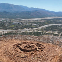
It is worth noting that a 2008 study made by the ΥΠΕΧΩΔΕ (Ministry for the Environment, Physical Planning and Public Works) mentioned remarkable ecosystems and natural landscapes in the wider region of Palaiochora that include the remaining Byzantine churches and windmills on the route from Aegina to Aphaia, the Kourenti spring (whose estuary is in Palaiochora) and the geological formation known as the “Broken/Spasmeno Vounaki” which is of particular scientific interest. This study ends by proposing the protection of the specific region that will significantly upgrade the appearance of Palaiochora.
The proposed route for trekkers and nature lovers can cover an expanse of the region previously discussed and can either start or end in Palaiochora, attracting the attention of nature lovers, botanists as well as geologists.
Restoration work
Throughout the settlement there are scattered piles of rubble, the remains of secular architecture and fortifications. It therefore becomes necessary to identify and restore them, on the basis of the number of finds. This will help in the morphological restoration both of part of the houses, some of which are founded on the walls, but also of the fortifications as for example in the castle area. On this spot there are two badly preserved cisterns and towers which immediately need to be strengthened by using existing materials and by the addition of new ones when necessary (fig. 6).
Taking into consideration the restoration of the appearance of the settlement’s network of paths as well as the paving material, it is proposed that the destroyed footpaths be remade. The paths that need direct restoring are the following: the track off the lower main path that leads towards Aghios Euthymios and the churches of the Dormition of Aghia Anna and its neighbouring church of Aghia Aikaterine, the path leading from Aghio Spyridon towards Aghia Kryfte and Aghios Zacharias which is completely destroyed and makes it dangerous to approach both churches. Next , there is a need to fix the path that connects the three churches of Aghios Eleutherios, Aghios Menas and Aghia Makrina (the existence of a bevel indicates that this particular spot was frequented in the past), as well as the path leading to Aghios Stylianos (near Panagia Giannouli) which is destroyed and so the church cannot be approached. Last, the path leading to Aghios Kerykos must be restored and linked directly both to the castle and to Aghios Stylianos because the church is no longer accessible. It is worth mentioning that there is also a need to directly restore the path for which a basic lay out exists and which joins the church of Aghios Kerykos with the Episcope.
As found after a recent autopsy (note 9) on the site, the following churches which are in ruins, need urgently to be restored: the church of Aghios Athanasios whose roof has completely caved in and whose wall paintings are badly cracked. In the case of Aghia Varvara it is suggested that it not only be restored but that part of the masonry and dome structure be rebuilt because the church has lost, to a great extent, its original appearance. Panagia Giannouli also has overall structural and stability problems while there are very few remains of the south aisle and it is no longer evident that it was once an example of a twin church. Last, work needs to be done immediately on the monks’ cells opposite the convent of Aghia Kyriake as their roof has completely collapsed and the masonry has quite a few damaged stone elements.
Since the first visit to Palaiochora in 2009 it was already too dangerous to access the churches of Aghia Kryfte and Aghio Zacharia. As a result, there has been no assessment of their condition. It is therefore probable that having repaired the paths leading there, the two churches mentioned above will be found belonging to the category in need of immediate restoration, given the general state of preservation of monuments yet to be restored in the medieval settlement of Palaiochora.
Specialized work on the stabilizing and restoration of each monument will be the object of study for a team of architects and civil engineers as part of an extensive programme proposed for the medieval settlement. A general assessment of damages will be presented here.
One of the main sources of damage is the rising damp, which means that drainage work has to be done on the water in the churches’ foundations. Regarding the masonry, it is proposed that the original damaged mortar be replaced, that cement mortar be removed, the biological crust cleaned as well as stabilizing operations being carried out by sealing the cracks and carrying out injections for sealing purposes. In the churches’ dome structures there are mainly stability and waterproofing problems which will be dealt with accordingly.
The damaged doors and windows of the churches will be replaced. Last, as regards the floors of the churches, it is proposed that those covered either with cement or tiles (of the French type) should be replaced with a paved floor in keeping with the traditional architecture of Palaiochora.
Christina Daltagianni
Archaeologist, Art Historian
Postgraduate Degree in the Management of Monuments