At a time of rapid changes related to issues of rural space, the need for both a deeper understanding of the multidimensional nature of today’s landscape and more systematic action for its protection and promotion are the factors shaping our demand for a more complete response to its management. This is coupled with the Greek State’s sanctioning, three years ago, of the European Landscape Convention. The Navarino Bay region in Pylos of Messenia is a uniquely important cultural landscape which is being put under considerable pressure by current trends involving the modifying of space. This article (note 1) will be studying the evolution of the bay’s landscape through time and investigating its existing state of preservation so as to present, at a theoretical level, possibilities both for its development and promotion prospects. Realizing that, as far as management planning is concerned, there is a lack of uniform treatment in the study of the region, a holistic approach is being attempted by looking at it as a complex of features namely ecological, social economic and cultural with an aim to enhance and promote its values.
A basic aim of this article is to make a composite proposal for the landscape’s management and its rational development by properly exploiting its comparative advantages.
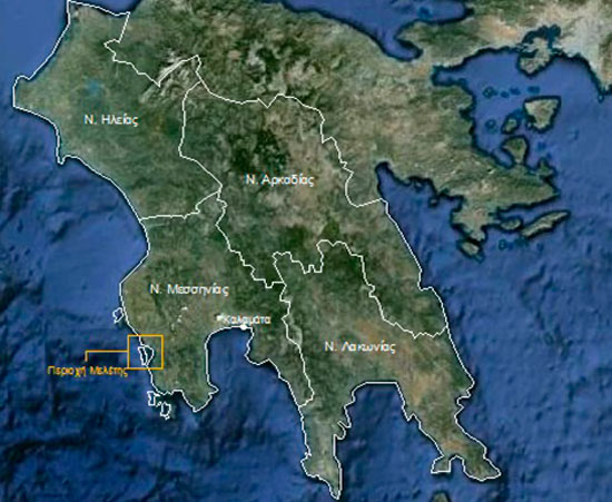
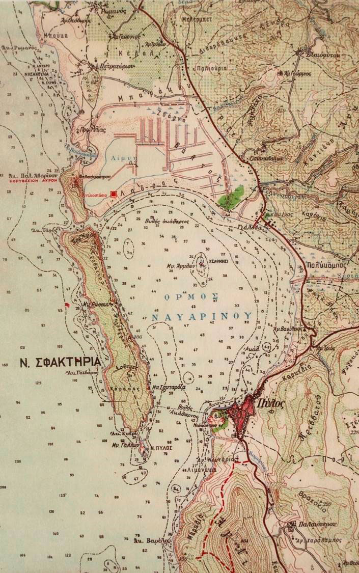
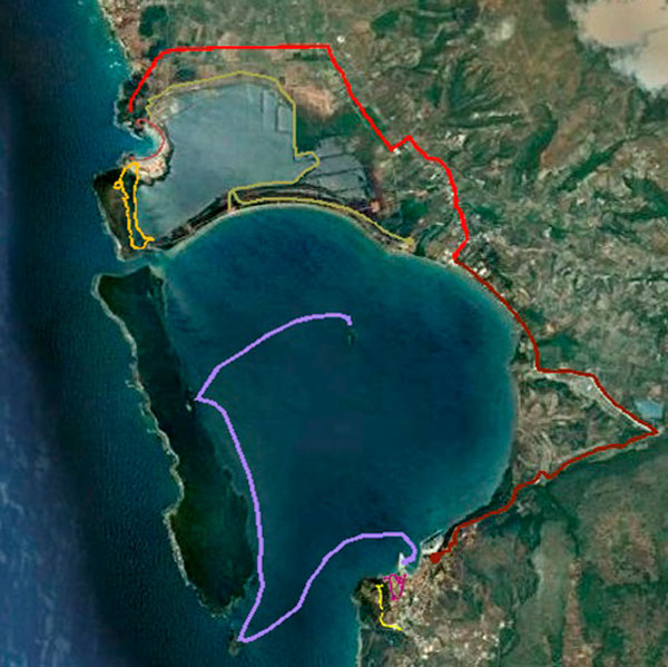
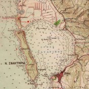
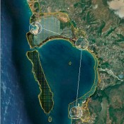
The region being surveyed (note 2) is situated in the south western part of the district of Messenia and has the Koukouras heights as its natural boundary to the west, the coastal zone between Pylos and Gialova to the east, the northern foothills of Agios Nikolaos to the south and the Ionian Sea to the west (fig. 1-3). It includes the Bay of Navarino with the modern town of Pylos and the hill of Niokastron at its southern tip. Six klms north of Pylos and on the Navarino Bay’s coastal strip of land is the modern community of Gialova, while to its north is the lagoon of Gialova or Divari (note 3). The small semicircular bay of Voidokoilia spreads to the west of the lagoon and towards the Ionian sea. Its natural boundaries to the north and south are the hill of the Prophet Elias and the Koryphasion peninsular respectively. The Koryphasion peninsular extends to the south reaching the so called “Fig Passage” which makes up the Bay of Navarino’s narrow northern entrance from the Ionian sea. To the south of this entrance stretches the oblong island of Sphakteria which protects the bay from the waves of the Ionian Sea. The bay’s southern main entrance is to be found between the southern tip of Sphakteria and the northern foothills of Aghios Nikolaos. The islet of Helonesi is situated inside the bay.
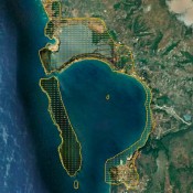
The region of the bay of Navarino resulting from intense geological activity, is known for the great variety of its landscape. It is one of the Mediterranean’s biggest natural harbours and the most recognizable landscape in western Messene with features such as its rock formations and islets, its coast including the wetlands of the Gialova lagoon which are, internationally, the most important southern wetlands in the Balkans and the small bay of Voidokoilia (Ox belly). Valuable ecosystems are encountered in the region as well as important species of flora and fauna some of which are of interest to the European Union, as they, the species, are either endangered or endemic. Furthermore, the uses of the region through time as testified by the landscaping and the density of monuments of all periods reveals the constant interaction between man and nature.
The holistic approach to the region being studied was also dictated by its actual physiognomy, as it has an unbroken historical, ecological and aesthetic unity. Because of its value on so many levels, it has been designated by law as a protected region. The bay of Navarino itself has been declared a historical site and moreover, its wider area is described as an archaeological site and a landscape of exceptional natural beauty. The lagoons’ ecosystems, the beach of the Voidokoilia bay, the bay of Navarino and Sphakteria island are all a single complex of habitats that are highly important to Greece and have been included in the European network Natura 2000.
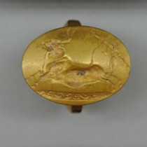
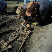
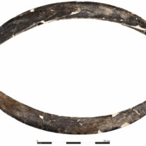
The first traces of man’s presence in the region being studied go back to the Stone Age, while in the Neolithic period there is evidence of use of the cave of Nestor which is situated on the north eastern slope of the Palaiokastron hill. A settlement of the Early Helladic era, a Middle Helladic tumulus and a Mycenaean vaulted tomb have all been found on the jetty in the northern part of the Voidokoilia bay, opposite the cave. In the centuries following the destruction, around 1200 BC, of the Mycenaean palace of Pylos on the hill of Ano Englianos, there is a population decline in the region and limited cultural activity. The Late Geometric period sees the start of Sparta’s control of Messene which lasts till the founding of the new Messenian state in the 4th c BC. During the centuries of the Spartan occupation, the centre of the settlement, in the region being studied, is moved to the southern jetty of the Voidokoilia bay, to the Koryphasion peninsular where the new city-state of Pylos develops as of the Classical period, keeping the name “Pylos Hemathoeis” after the Homeric Pylos of Englianos. After the liberation of the Messenian helots and the founding of Messene, Pylos of Koryphasion is declared an independent city in 362BC and flourishes during Hellenistic and Roman times. This can be testified by the extensive city cemetery to the east of the Palaiokastron hill which was situated on land that was later flooded by the waters of the lagoon.
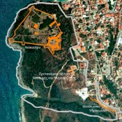
Palaiokastro (1282-1289) is built during the Frankish period on the ruins of the ancient Koryphasion citadel. It lived through consecutive Venetian and Ottoman conquests, while in the times of the first Ottoman rule, when realizing the strategic importance of the location in controlling the Balkans, the Ottomans also build a second fortress on the southern tip of the Navarino bay, called New Navarino or Niokastron. At the start of the Revolution of 1821, Niokastron and the surrounding area pass to the Greeks, while in 1825, after the battle of Sphakteria they are occupied by the Turkish Egyptian forces remaining thus till the final act of the Greek Revolution, the naval battle of Navarino on the 20th of October 1827, resulting in the Ottomans evacuating southern Greece and the borders of the modern Greek state being made definite. The Turkish Egyptian departure was followed by the arrival in Pylos, by demand of the Great Powers, of the French expeditionary force led by General Maison, which stayed till 1833. The modern new town of Pylos, whose basic urban network has been maintained till now, is founded between 1828 and 1833 with town planning by French engineers. From the end of the 19th and through the 20th century, monuments have been erected in Sphakteria, the Pylos islet and the Helonaki (Small Tortoise) island as well as the monument of the Three Admirals in the square by that name in Pylos, in honour of those who fell in the naval battle of Navarino
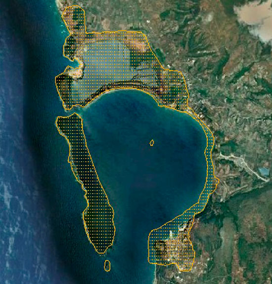
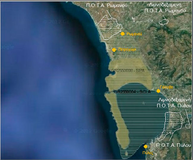
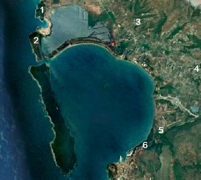
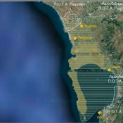
The region being studied is an ideal destination, because of its natural beauty, its unique past and its cultural wealth. Lately it is undergoing a great deal of pressure mainly from the unscheduled planning of tourist resorts and holiday villas in the coastal zone coupled with the incompatibility of different uses of the land made worse by no previous town planning at a higher level. The landscape in the area at large is changing radically due to the organization of the Regions for Integrated Development of Tourism (Π.Ο.Τ.Α.) in the district of Messenia. Investments in Pylos and the Romanos area are partly within the limits of the internationally protected habitats of Pylos, Gialova and Sphakteria (fig. 4). The choice of investment in a region of great environmental and historical value substantially affects its ecological balance and production base by imposing, for the first time, specific uses of land in a Natura region outside a town or village, changing its agricultural nature to that of a tourist resort.
At the same time, other manmade activities help to spoil the look of the region being studied. These involve rubbish and rubble disposal on the beaches of Divari and Voidokoilia. There is also considerable pressure put on important habitats, such as those with white dunes and those with cedars particular to that area, to avoid illegal camping, the parking of vehicles and the use of beaches for mass recreation.
Moreover, there is significant strain put on the environment by liquid waste from units, in neighbouring communities, for the treatment of olive oil, as this waste pollutes the stream of “Xerolangados” surrounding the lagoon. The environment also suffers from the mooring of merchant ships in the bay of Navarino and the pollution of the beaches with tar created by the frequent spill of petrol hydrocarbons from passing tankers. Poaching and illegal fishing are likewise thought of as unfavourable factors as is the decline of the lagoon’s biodiversity by the trespassing on expanses of wetland to convert them to rural land and also excessive fishing in the bay of Navarino.
The existing state of landscape preservation has been evaluated as relatively satisfactory, bearing in mind to what degree habitats are natural, the level of preservation of both structures and functions, threatening situations coupled with possibilities for improvement and restoration. Nevertheless, if an explicit policy for the organization of rural space is not directly implemented with an aim to reinforce the region’s protection, it is estimated that the region’s levels of vulnerability will rise, as a result of the intensity of human activity in the area, which will lead to the habitats’ downgrading and to the landscape deteriorating aesthetically. In respect to the state of conservation of monuments in the surveyed region, it should be noted that this is quite satisfactory as, in most of them, the architectural form has been preserved as well as a considerable amount of the actual materials used for their construction. Monuments are an important source of information on the cultural development of the surveyed region as they are representative of many different periods in history. Nevertheless, the sight presented nowadays by most of the areas with monuments does not correspond to their importance as no care has been taken for their complete protection and no necessary operations have been undertaken for them to become archaeological sites for visiting.
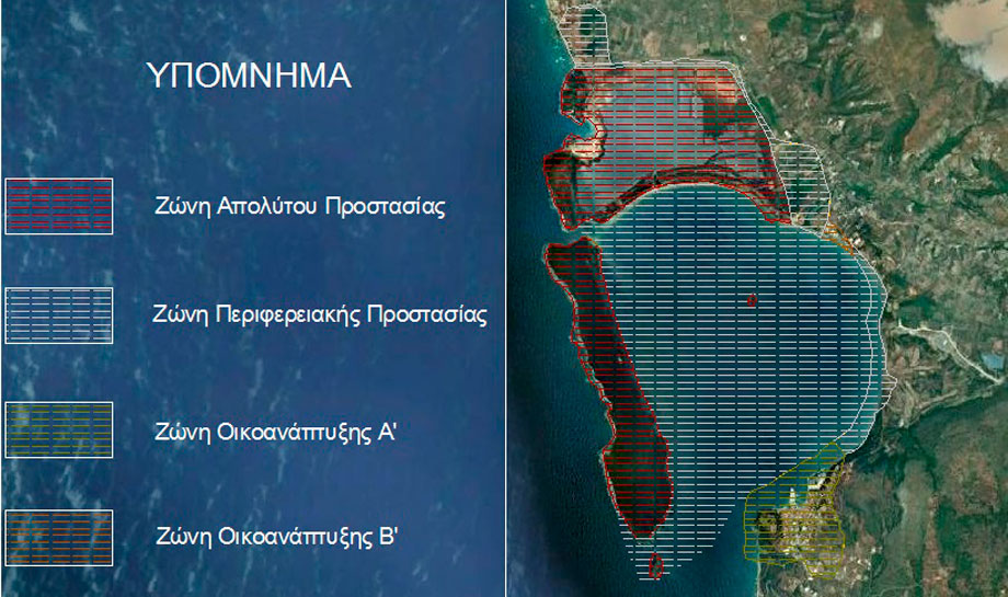
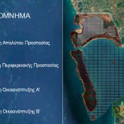
The strategic target for the long term management of the surveyed region is the protection and enhancement of its cultural landscape in view of its being approached as a living experience by both its inhabitants and visitors to the area. In order to strengthen the landscape protection regime, the establishing of protection zones are to be recommended in the Natura region that already functions within an institutional framework. This would deter the choice of locations for incompatible uses of land. The Residential Control Zones (Z.O.E.) are recommended as a successful institution for protection purposes, where specific uses of land are determined together with building restrictions. The proposed Z.O.E. is divided into four individual protected regions: the Absolute Protection Zone, The Regional Protection Zone, the A Zone for Eco development and the B Zone for Eco development (fig. 5).
In the Absolute Protection Zone the only uses allowed are those compatible with the region or judged as necessary for its protection, as well as uses related to the enhancement of protected land, such as the opening of paths and cycling routes, implementing operations to restore sites with monuments , the carrying out of small scale works for a site’s surveillance, such as the creation of places for viewing the landscape and the setting up of observatories for bird watching, the information of the public and additional signposting. Within the zone, building of any type is not allowed, neither is the concession of public land as property or for use. The Regional Protection Zone functioning as a transitional zone from the strictly protected sensitive ecosystems to the agricultural ecosystems, seeks to maintain both its character as a whole and its ecological function by allowing small scale changes which do not cause the landscape to be downgraded or to deteriorate aesthetically. Operations considered as decisive in regards to the aquatic expanse of the Navarino bay are the systematic underwater research survey for the digital mapping of the sea bed, the demarcation of zones in the designated marine archaeological site and the setting of terms for carrying out sea activities. In the Zones for Eco Development A’(note 4) and B’ ,in the region of ecotourism in Pylos and the region of the Gialova settlement, respectively, the aim is to protect and enhance their particular features both natural and cultural, as well as to moderately develop the regions’ productive activities by promoting alternative forms of tourism.
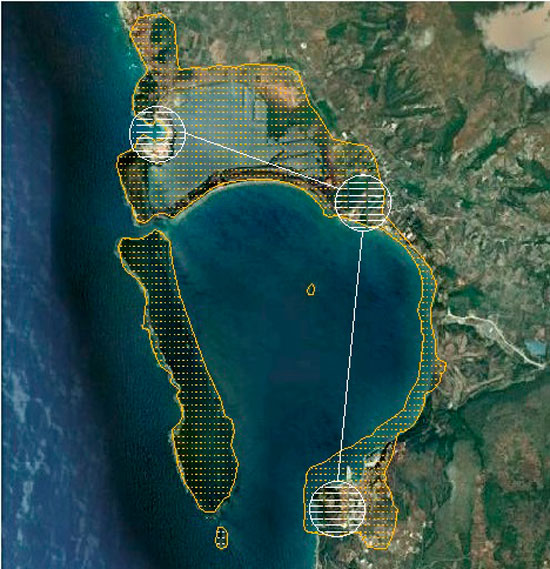
In order to completely enhance elements of natural beauty in the surveyed region, as well as utilizing and promoting features that make up its historic and cultural physiognomy, it would be recommended to both integrate and link them within a single network of environmental and cultural interest. The infrastructure’s main idea is centred round the concept of transmission, in several directions, from the multi centred network’s operations area which holistically interprets the region’s cultural development. The various types of landscape and wetland are recognized as the network’s basic components which include the remains of monuments in the surveyed region, as well as a web of country routes. The latter can function as an applied method for interpreting the cultural landscape which, method, aims to educate visitors,make them more aware and contribute to their recreation. The Multi Centre Environmental and Cultural Network has the following basic points of reference: the Reception and Information Centre for Visitors to Pylia which will have a central spot in the town of Pylos as a proposed choice of location, the Environmental Awareness and Ecotourism Centre in Gialova and the Open air Museum in the bay of Voidokoilia (fig.6). By functioning in a complementary manner these junctions simultaneously collect and diffuse available information and knowledge related to historical, ecological and aesthetic features of the surveyed region. This infrastructure is reinforced with smaller, individual information stations, raised platforms for panoramic views (belvedere) and organized areas for customer service.
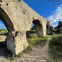
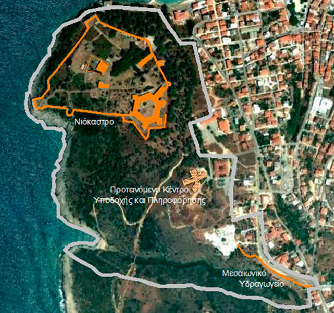
The proposed single archaeological park on the west side of the Pylos community is designated the network’s first reference point. This park is shaped by unifying Niokastron with the medieval Aqueduct, while by reusing the deserted building of the old Red Cross hospital as a Reception and Information Centre for Visitors to Pylia, the region can be expected to become the starting point for the public touring the wider area of the Navarino bay (fig. 7). The network’s second reference point is the Environmental Awareness and Ecotourism Centre in the region of the Gialova community which will contribute substantially both to the systematic environmental and cultural briefing of the local society and of the public at large as well as to its education and awareness concerning the need for protection and rational management of the region’s wetland ecosystem. The abandoned industrial buildings of the Gialova community, when properly put to use, are seen as the premises of the aforementioned centre, following their evaluation and their being declared listed buildings. The environmental, archaeological and aesthetic importance of the landscape of Voidokoilias bay, make it an ideal area to be appointed an Open Air Museum establishing it as the network’s third reference point. The Open Air Museum, functioning as a interpretive tool for approaching the region’s distant past, transforms the monumental remains in to an archaeological site both readable and instructive.
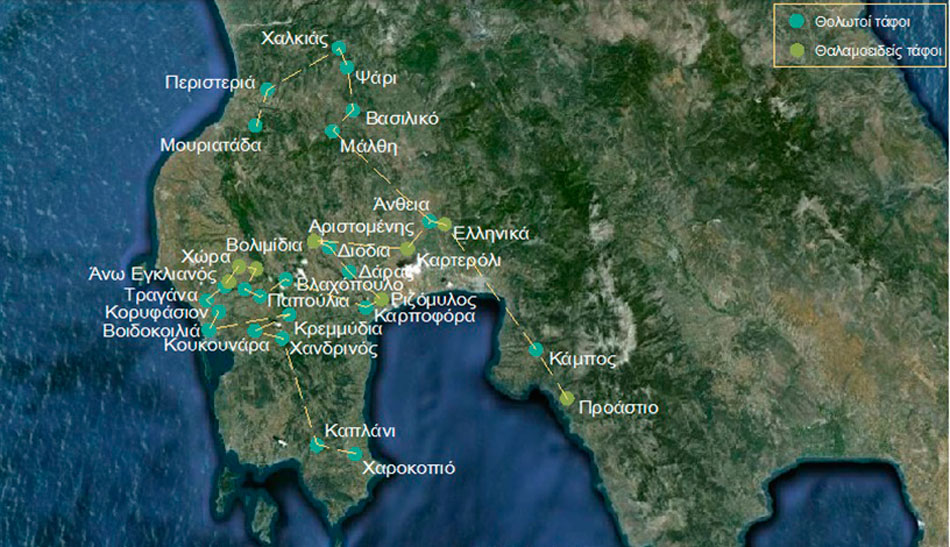
In prominent spots of the network’s three junctions mentioned above, an informative map of the surveyed area will be put up showing the proposed network of nine environmental and cultural corridors (fig. 8). To strengthen the perception and understanding of the landscape’s structure, six interesting locations for a panoramic view of the surveyed region, will be included in the visitors’ touring network. These will function as resting spots and as places for having an overall view of the landscape (fig. 9). The multi centre network of the surveyed region can become part of a broader touring network of the Messenia district. Maps of the district will supply the public with information related to visiting other cultural entities in Messenia, while there will be reminders of suggested theme trips (e.g. a network of visits to vaulted and chamber Mycenaean tombs (fig. 10), a visiting network to Byzantine and post Byzantine monuments, a visiting network to castles). To form an overall view of Messenia’s cultural development through the centuries, the public will be encouraged to start its tour of the district from the Archaeological Museum of Messenia in the heart of the Kalamata’s historical centre which, museum, presents in a thorough manner the region’s antiquities from prehistoric times to the Byzantine period.
In conclusion, it becomes apparent that the management and enhancement of the landscape of today is a demanding subject where planning is concerned, requiring the study and estimation of multiple variables. In both the continuous transformation process of the Greek countryside and the exhausting pressure put on by multiple and often conflicting demands, the environmental and cultural features of a landscape are the main elements that determine its identity and become signs of a collective memory. It is necessary to promote a holistic approach to the landscape as being a public asset and to enhance its multiple values. This comes in contrast to the state’s approach to urban and rural planning which is geared towards broadening jurisdiction in the construction and tourist industry at the expense of natural and cultural resources. Consequently the existing legal framework is reinforced, allowing construction outside the urban network, in Natura districts and in landscapes of exceptional natural beauty. The case chosen in the present article concerning the management and enhancement of the bay of Navarino’s landscape is typical to the problem mentioned above. The preservation of the existing landscape as an irreplaceable resource both natural and cultural and as an inexhaustible well of archaeological historical and cultural evidence, urgently calls for the reinforcement of the protection regime. It also calls for the recognition of its, the landscape’s, diversity on a natural, functional, morphological, historical and ideological level and its treatment as an entity, aiming at a complete interdisciplinary plan for intervention. Conditions are complex for winning over single local perceptions and consciences at an existential level. It will, however, prove decisive for the preservation of the unique features both geographic and cultural of the surveyed region.
Iro-Alexandra Valsamakis
Archaeologist, MA in Management of Monuments
Archaeologist at the sub-project “Archaeological Work for the construction of a new Protective Roof of the Palace of Nestor” which is being carried out by the 38th Ephorate of Prehistoric and Classical Antiquities as part of the project “Construction of a new protective roof of the Palace of Nestor in Upper Englianos of New Messinia”.