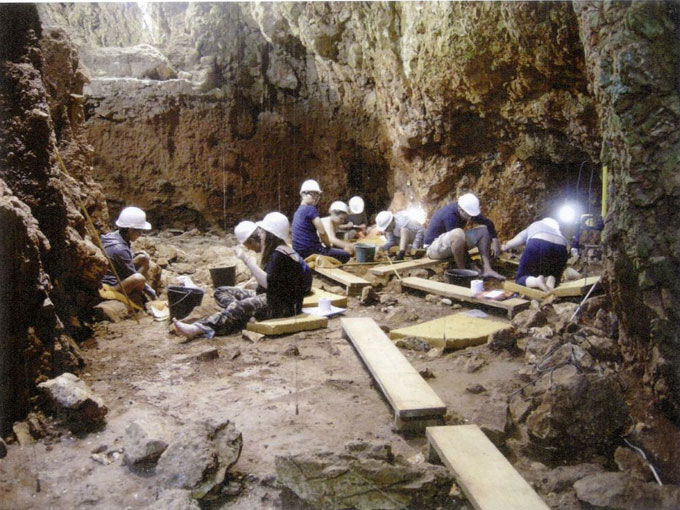
Early humans who lived 170,000 years ago were able to heat their cave efficiently and safely, by placing hearths on spots allowing for the smoke to come out of the living space, securing optimal ventilation and heating conditions. This is what experts from Tel Aviv University found out, having developed a software-based smoke dispersal simulation model which they then applied to a prehistoric (Acheuelean/Mousterian) site in Lazaret Cave, France.
According to the abstract of the study, published at the journal Scientific Reports, the team of Ph.D. candidate Yafit Kedar, Prof. Ran Barkai (both at the Jacob M. Alkow Department of Archaeology and Ancient Near Eastern Cultures at TAU), and independent researcher Dr. Gil Kedar, analysed the influence of hearth location and smoke dispersal on potential activity areas at Lower Paleolithic Lazaret Cave, France, a Lower Paleolithic (Acheuelean/Mousterian) site excavated by French archaeologist Prof. Henry de Lumley and his team. The team focused on a single hearth known from an archaeostratigraphic unit coded as UA25, as the area is well documented through GIS and activity area analysis. In the study, researchers considered two main parameters: heat and smoke. They first selected 16 hypothetical hearth locations. Then, using the Fire Dynamic Simulator (FDS) (an application developed by Israel’s National Institute of Standards and Technologies), they simulated smoke dispersal from these 16 locations, analysing effects on potential working spaces. To measure/evaluate these effects in the environment of the cave, the team took account of the average smoke exposure recommendations from the World Health Organization (WHO) and Environmental Protection Agency (EPA), thus defining four activity zones in the cave.
The findings were eye-opening. As mentioned in the abstract, the simulation results showed an optimal hearth location zone of about 5 × 5m2, and it is precisely in this zone that the Lower Palaeolithic humans of Lazaret Cave placed their hearth. They then demonstrated that the optimal hearth location zone correlates not only with the archaeological hearth in UA25 but also with the locations of hearths in other layers in the cave. In particular, analysis of hearth locations in archaeostratigraphic units UA26, UA27, UA28, UA29 showed that the majority of hearths were located in the preferred zone, something that allows researchers to propose that their suggested hearth location parameters are appropriate for all occupation levels at Lazaret Cave. It is possible then to say that the size of the low smoke density area and its distance from the hearth were the main parameters for choosing hearth location, and that the prehistoric inhabitants of Lazaret Cave had developed the ability to define these parameters and utilise them to improve their living conditions. Finally, smoke simulations by the Israeli team confirm the accuracy of the excavators’ GIS and activity area reconstruction, as the suggested activity areas correlate well with the smoke dispersal parameters, strongly reinforcing their interpretation regarding the spatial organisation of human behaviour at Lazaret Cave.