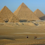
A team led by Eman Ghoneim, a University of North Carolina Wilmington Earth and Ocean Sciences professor, has confirmed the pyramids in Egypt were built along a now abandoned branch of the Nile River, highlighting the importance of the river as a cultural artery and demonstrating how humans have historically been impacted by environmental change.
These findings are being reported in a research paper in Communications Earth & Environment. They could explain why the pyramids are concentrated in what is now a narrow, inhospitable strip of the Saharan Desert.
“Many of us who are interested in ancient Egypt are aware that the Egyptians must have used a waterway to build their enormous monuments, like the pyramids and valley temples, but nobody was certain of the location, the shape, the size, or proximity of this mega waterway to the actual pyramids site,” said Ghoneim. “Our research offers the first map of one of the main ancient branches of the Nile at such a large scale and links it with the largest pyramid fields of Egypt.”
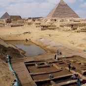
The Egyptian pyramid fields between Giza and Lisht were built over a 1,000-year period starting approximately 4,700 years ago. They now sit on the edge of the inhospitable Western Desert within the Saharan Desert. Sedimentary evidence suggests the Nile used to have a much higher discharge, with the river splitting into several branches in places. Researchers have previously speculated that one of these branches may have flowed by the pyramid fields, but this has not been confirmed.
Ghoneim and her colleagues studied satellite imagery, geophysical surveys, and sediment samples to confirm the location of the former river branch; which they propose naming Ahramat, meaning pyramids in Arabic. The researchers suggest an increased build-up of windblown sand, linked to a major drought which began approximately 4,200 years ago, could be one of the reasons for the branch’s migration east and eventual silting up.
The work was funded by a grant from the National Science Foundation awarded to Ghoneim, University of Memphis Associate Professor Suzanne Onstine, and Macquarie University Associate Professor Tim Ralph.
The discovery may explain why these pyramid fields were concentrated along this strip of desert near the ancient Egyptian capital of Memphis, as they would have been easily accessible via the river branch at the time they were built. Additionally, Ghoneim and her colleagues found many of the pyramids had causeways that ended at the proposed riverbanks of the Ahramat branch, which they suggest is evidence the river was used for transporting construction materials.
Future research to find more extinct Nile branches could help prioritize archaeological excavations along their banks and protect Egyptian cultural heritage.
Update: a response to the announcement has been shared by Dr. Zahi Hawass & Dr. Mark Lehner via the former’s profile page on Facebook.