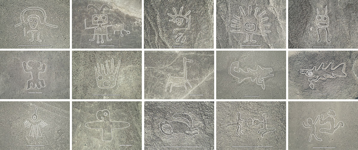
The joint study between Yamagata University Institute of Nasca and IBM Research has been accepted in the Proceedings of the National Academy of Sciences (PNAS) for publication about “AI-accelerated Nazca survey nearly doubles the number of known figurative geoglyphs and sheds light on their purpose”. With the help of Artificial Intelligence, which analyzed vast amount of geospatial imagery data from airplanes to identify priority areas of likely geoglyphs for field surveys, the team discovered and documented 303 new figurative geoglyphs in only six months. This represents a 16 fold increase in the rate of discovery by using IBM’s AI. This significantly improved data set of relief-type figurative geoglyphs reveals that they differ from line-type figurative geoglyphs beyond their style, size and spatial distribution. The line-type and relief-type also differ in the motifs they depict and their associations with the networks of linear and trapezoidal geoglyphs (in the case of line-type) and winding trails (in the case of relief-type), respectively. While line-type figurative geoglyphs were created for community ceremonial purposes, relief-type geoglyphs were created to serve as “billboards” to be seen from the trails to share information about human activities, mainly related to domesticated animals and decapitated heads.
Background
The Nazca geoglyphs are famous as a UNESCO World Heritage Site. Created at least 2,000 years ago, they were discovered in the 1920s, and until this work, 430 figurative geoglyphs, such as animals, plants and tools, have been identified. Using remote sensing technology (satellites, airplanes, drones), 318 of these were discovered by Yamagata University Institute of Nasca. However, the Nazca Pampa is a vast area of 400 square kilometers, so surveying the entire area on foot as well as manually inspecting all the high resolution aerial imagery would take a prohibitive amount of time. To accelerate this survey, Yamagata University and IBM Research have partnered to use IBM’s advanced Artificial Intelligence technologies, which has led to this publication accepted by the Proceedings of the National Academy of Sciences (PNAS)
Research Methods and Results
One of the challenges of using AI for geoglyph discovery is the limited amount of training data. To address this challenge, IBM Research developed an AI model which is able to work with just a few training samples while still being very performant. This model was able to identify areas with likely geoglyphs. We only had to screen an average of 36 of these AI-model suggestions to find one likely candidate – a game changer for this kind of work. A total of 1309 likely candidates were identified and field surveys of about a quarter of them resulted in 303 new figurative geoglyphs within only 6 months of field survey, nearly doubling the number of known figurative geoglyphs. The improved data set of figurative geoglyphs enables us to analyze their motifs and spatial distribution across the Nazca Pampa. Relief-type geoglyphs depict mainly human motifs or motifs of things modified by humans, such as domesticated animals and decapitated heads. They are typically located within viewing distance of the winding trails that crisscross the Nazca Pampa and were most likely built and viewed at the individual or small-group level. On the other hand, the giant line-type figurative geoglyphs mainly depict wild animals. They are distributed along the elaborate linear/trapezoidal network of geoglyphs, which suggests that they were probably built and used on a community-level for ritual activities.
Future Prospects
-Further improvements in AI’s ability such as the use of IBM’s geospatial foundation models could lead to even more sophisticated results.
• By conducting field surveys of the remaining 968 candidates that we identified as likely geoglyphs, it is possible that an even larger number of new geoglyphs will be discovered through this work.
-As a result of our AI-based field surveys, we believe that there are more than 1000 relief-type geoglyphs distributed along more than 100 trails. In the Andean civilizations, which did not have a written language, there are many cases where socially important information was incorporated into the combination of images drawn on pottery, walls, cloth, etc. We believe that the distribution of over 1000 Nasca geoglyphs contains information that was important to the Nasca society. Therefore, we will work to decipher this information.
-To recreate the geoglyph-related visual experience of walking the trails of the Nazca Pampa using LIDAR data.
-New opportunities for AI exist by addressing the speed and accuracy of dating the pottery distributed along the geoglyphs.
-Using the LIDAR data, we will be able to identify geoglyphs that are likely to be impacted by severe flood events caused the excessive rain in the nearby mountains, with the goal to work with the Peruvian Ministry of Culture to develop activities to protect them.


